

- Usage in publication:
-
- Tyee sandstone*
- Modifications:
-
- Original reference
- Dominant lithology:
-
- Sandstone
- Shale
- AAPG geologic province:
-
- Western Columbia basin
Summary:
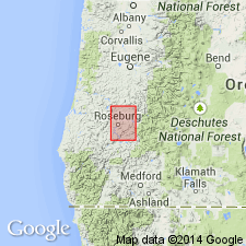
Tyee sandstone. Massive sandstone with occasional shales. Thickness 1,000 feet in Roseburg quadrangle. Differs from underlying Umpqua formation in sandstones being heavier-bedded and containing more conspicuous mica scales. Forms prominent escarpment from Tyee Mountain to Camas Valley. Eocene fossils. Age is Eocene.
[Named from exposures at Tyee Mountain, about 9 mi southeast of Kellogg, in northwestern part of Roseburg quadrangle (scale 1:125,000), Douglas Co., western OR. Recognized in southwestern and northwestern Oregon, as far north as Tillamook County.]
Source: US geologic names lexicon (USGS Bull. 896, p. 2205).
- Usage in publication:
-
- Tyee sandstone
- Modifications:
-
- Areal extent
- AAPG geologic province:
-
- Western Columbia basin
Summary:
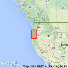
Tyee sandstone (upper Eocene) is 2,000 feet thick. Extends from type locality, in Douglas County, southward to Rogue River Mountains [southwestern Oregon], and northward 120 miles into Tillamook County [northwestern Oregon].
Source: US geologic names lexicon (USGS Bull. 896, p. 2205).

- Usage in publication:
-
- Tyee sandstone
- Modifications:
-
- Areal extent
- AAPG geologic province:
-
- Western Columbia basin
Summary:
Pg. 6-7. Tyee sandstone. Gave thicknesses of Tyee sandstone as 2,500 feet in Roseburg quadrangle, 5,000+ feet at Florence, Lane County, and 4,000+ at Newport, Lincoln County, and placed it below Coaledo formation, but stated that Tyee of Florence and Newport doubtless includes same horizon as Coaledo of Coos Bay. [Age is Eocene.]
Source: US geologic names lexicon (USGS Bull. 896, p. 2205).
- Usage in publication:
-
- [Tyee sandstone]
- Modifications:
-
- Areal extent
- AAPG geologic province:
-
- Western Columbia basin
Summary:
Pg. 458. Published same statements as Harrison and Eaton regarding thickness and placed Coaledo above Tyee. [Age is Eocene.]
Source: US geologic names lexicon (USGS Bull. 896, p. 2205).
- Usage in publication:
-
- Tyee sandstone
- Modifications:
-
- [Biostratigraphic dating]
- AAPG geologic province:
-
- Western Columbia basin
Summary:
Pg. 24. Tyee sandstone. On basis of superposition the Tyee is to be regarded as = Coaledo formation, of Tejon age. However, characteristic Meganos fossils have been collected from typical Tyee sandstone from places other than type locality of Tyee, an obvious discrepancy that has not yet been explained. [Age is Eocene.]
Source: US geologic names lexicon (USGS Bull. 896, p. 2205).
- Usage in publication:
-
- Tyee formation
- Modifications:
-
- Redefined
- Mapped
- Dominant lithology:
-
- Sandstone
- Mudstone
- AAPG geologic province:
-
- Western Columbia basin
Summary:
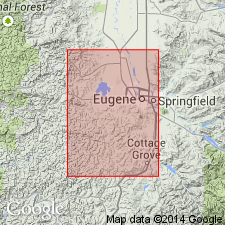
Tyee formation. Described in Eugene area as Tyee formation since here beds include substantial proportion of mudstone. Thickness about 5,000 feet; base not exposed. Unconformably underlies Lorane shale member of Spencer formation (restricted). [Age is middle Eocene.]
Source: US geologic names lexicon (USGS Bull. 1200, p. 4000-4001).
- Usage in publication:
-
- Tyee formation
- Modifications:
-
- Mapped
- Dominant lithology:
-
- Sandstone
- Siltstone
- AAPG geologic province:
-
- Western Columbia basin
Summary:
Tyee formation. Described in Corvallis area where it overlies Kings Valley siltstone member of Siletz River volcanic series and underlies Spencer formation. Mapping in Corvallis-Monroe area indicates that Lorane shale member is more closely related to Tyee formation than to Spencer formation. Correlation is suggested between siltstone in upper part of Tyee in Monroe and Albany quadrangles and Lorane shale member of Spencer formation. [Age is middle Eocene.]
Source: US geologic names lexicon (USGS Bull. 1200, p. 4000-4001).
- Usage in publication:
-
- Tyee formation
- Modifications:
-
- Mapped
- Dominant lithology:
-
- Sandstone
- Siltstone
- AAPG geologic province:
-
- Western Columbia basin
Summary:
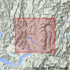
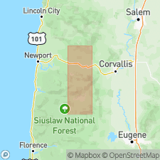
Tyee formation. Described in Marys Peak and Alsea quadrangles [Polk, Lincoln, Benton, and Lane Counties, western Oregon] where it overlies Siletz River volcanic series, where it consists of thick series of rhythmically bedded sandstone and intercalated siltstone. This same sequence of sedimentary rocks is exposed along Yaquina River in Toledo quadrangle and was named Burpee formation by Schenck (1927). Recent mapping has shown that Burpee formation is equivalent at least in part, to Tyee formation. Fossils. Inasmuch as name Tyee has priority, it is used in this report. Age is middle Eocene.
[GNC remark (ca. 1960, US geologic names lexicon, USGS Bull. 1200, p. 4001): U.S. Geological Survey restricts the use of the term Burpee to its type locality. Elsewhere the term Tyee is used.]
Source: Publication; US geologic names lexicon (USGS Bull. 1200, p. 4000-4001).
- Usage in publication:
-
- Tyee formation
- Modifications:
-
- Overview
- AAPG geologic province:
-
- Western Columbia basin
Baldwin, E.M., 1959, Geology of Oregon: Ann Arbor, MI, Edwards Bros., Inc., __ p.
Summary:
Pg. 13. Tyee formation. Near Lukiamute River appears to interfinger with Yamhill formation. [Age is middle Eocene.]
Source: US geologic names lexicon (USGS Bull. 1200, p. 4000-4001).
- Usage in publication:
-
- Tyee Formation
- Modifications:
-
- Overview
- AAPG geologic province:
-
- Western Columbia basin
Summary:
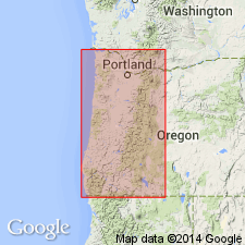
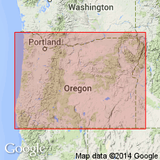
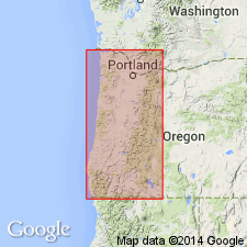
Pg. 7, 26, 45-46, corr. chart. Tyee Formation. Rhythmically bedded, cliff-forming, buff to greenish-gray sandstone and dark mudstone. Thickness about 7,000 feet. Includes rocks assigned to Burpee Formation [now abandoned] in older publications, and rocks assigned to Lorane Shale Member of Spencer Formation by Vokes and others (1951). Locally, in vicinity of Elkton, Sacchi Beach, and Eugene, upper part of formation is chiefly siltstone, thickness several thousand feet; rocks assigned to Elkton Siltstone Member, Sacchi Beach Siltstone Member, and Lorane Siltstone Member [revised], respectively. Unconformably overlies Umpqua Formation (southern Coast Range). Unconformably underlies Coaledo Formation (Coos Bay area), Spencer and Colestin Formations (central Coast Range), and Nestucca Formation (northern Coast Range). To north, grades laterally into lower part of Yamhill Formation. Fossils. Age is middle Eocene (probably late middle Eocene), based on stratigraphic relations and fossils.
Forms bulk of exposures of central Coast Range of Oregon from latitude of Salem southward to latitude of Myrtle Point; south of Myrtle Point exposures are isolated.
Source: Publication.

- Usage in publication:
-
- Tyee Formation*
- Modifications:
-
- Geochronologic dating
- AAPG geologic province:
-
- Western Columbia basin
Summary:
Pg. 26-27, geologic time scale (inside front cover). Tyee Formation (middle Eocene). Sandstone sample from [approx.] Lat. 44 deg. 41 min. N., Long. 123 deg. 52 min. W., Toledo quadrangle, Lincoln County, Oregon, yielded a Rb-Sr age of 168 +/-15 Ma (muscovite) [Jurassic]; average age of detrital muscovite. Age calculated using decay constants of Steiger and Jager, 1977 (Earth Planet. Sci. Letters, v. 36, p. 359-362).
Source: Publication.
For more information, please contact Nancy Stamm, Geologic Names Committee Secretary.
Asterisk (*) indicates published by U.S. Geological Survey authors.
"No current usage" (†) implies that a name has been abandoned or has fallen into disuse. Former usage and, if known, replacement name given in parentheses ( ).
Slash (/) indicates name conflicts with nomenclatural guidelines (CSN, 1933; ACSN, 1961, 1970; NACSN, 1983, 2005, 2021). May be explained within brackets ([ ]).