

- Usage in publication:
-
- Twisp Formation
- Modifications:
-
- Named
- Dominant lithology:
-
- Argillite
- AAPG geologic province:
-
- Okanogan province
Summary:
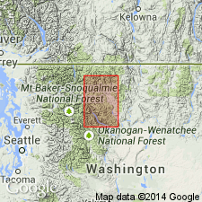
Type area designated as exposures in the channel walls of Methow and lower Chewack Rivers, between Twisp and a point two miles north of Winthrop [Lewis Butte 7.5' quad], Okanogan Co, WA. Oldest of two units of the Newby Group. Composed of very hard argillitic black shales, which characteristically weather into long, sharp, pencil-like fragments. Is thin-bedded with occasional interbedded dark volcanic siltstones. Thickness is estimated at 1220 m. Unconformably underlies the Buck Mountain Formation (new) (Newby Group). Age is Early to Middle Jurassic(?).
Source: GNU records (USGS DDS-6; Menlo GNULEX).
For more information, please contact Nancy Stamm, Geologic Names Committee Secretary.
Asterisk (*) indicates published by U.S. Geological Survey authors.
"No current usage" (†) implies that a name has been abandoned or has fallen into disuse. Former usage and, if known, replacement name given in parentheses ( ).
Slash (/) indicates name conflicts with nomenclatural guidelines (CSN, 1933; ACSN, 1961, 1970; NACSN, 1983, 2005, 2021). May be explained within brackets ([ ]).