

- Usage in publication:
-
- Twin River formation
- Modifications:
-
- Named
- Biostratigraphic dating
- Dominant lithology:
-
- Shale
- Sandstone
- AAPG geologic province:
-
- Olympic Mountains province
Summary:
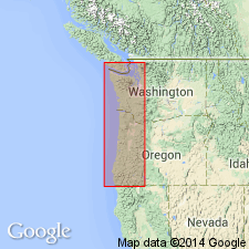
Named for Twin River, "the locality where the best fossil collecting was obtained", on south shore of Strait of Juan de Fuca, Clallam Co, WA. Type not designated. Is conformable above Seattle formation (new) in upper part of "Astoria series between Port Crescent and Pysht River ... extending from about three miles east of Twin River west nearly to Pysht Bay ... ". [Relation to overlying beds not given]. Is about 2000 ft thick, consisting of soft clay-shale intercalated locally with thin beds of sandstone that "wash out on the beach as flags." Abundant molluscan fauna, most undescribed, allow unit to be assigned to middle Oligocene age. Partial list of species and localities included in report.
Source: GNU records (USGS DDS-6; Menlo GNULEX).
- Usage in publication:
-
- Twin River formation*
- Modifications:
-
- Areal extent
- Age modified
- Overview
- AAPG geologic province:
-
- Olympic Mountains province
Summary:
Redefined to include mappable sequence of predominantly argillaceous sedimentary rocks in northern Olympic Peninsula. Mapped in detail along south shore of Strait of Juan de Fuca from McDonald Creek westward [40+ mi] to Clallam River; reconnaissance indicates it occurs 5 to 8 mi inland and is locally exposed along west shore of Olympic Peninsula. Some of the rocks were formerly included by Weaver (1937) in Lyre and Lincoln formations. Consists of three members: lower, thin-bedded sandstone and siltstone; middle, massive or thinly bedded siltstone; upper, massive mudstone with local lenses of conglomerate. Type locality designated along Deep Creek, north-flowing stream that enters Strait of Juan de Fuca at point 3.4 mi west of mouth of West Twin River. Type section is 16,500 ft thick at Deep Creek from point 3600 ft S 41 deg W from U.S. Forest Service road bridge across Deep Creek, northward to point on axis of local east-trending syncline, 700 ft east, 4350 ft north of SW/4 sec.20 T31N R10W, Clallam Co. Reference section for upper member is along coast from East Twin River [eastward 3.5 mi] to a point 0.5 mi northwest of Murdock Creek. Maximum thickness is 17,500 ft on south limb of Clallam syncline. Conformably overlies Lyre formation of Brown and others (1956). Conformably overlain by Clallam formation of Weaver (1937). Mollusks and Foraminifera indicate age range is late Eocene to early Miocene.
Source: GNU records (USGS DDS-6; Menlo GNULEX).

- Usage in publication:
-
- Twin River Group*
- Modifications:
-
- Revised
- Areal extent
- AAPG geologic province:
-
- Olympic Mountains province
Summary:
Raised in rank to group. Includes (ascending): Hoko River, Makah, and Pysht Formations (all new); which respectively equate to lower, middle, and upper members of Twin River Formation of Brown and Gower (1958). Age [remains] late Eocene to early Miocene. Geologic sketch map shows group extends from Midway, near Cape Flattery, eastward to more than 15 km east of Port Angeles and as much as 12 km inland [thus geographically extending group westward from Clallam River].
Source: GNU records (USGS DDS-6; Menlo GNULEX).
For more information, please contact Nancy Stamm, Geologic Names Committee Secretary.
Asterisk (*) indicates published by U.S. Geological Survey authors.
"No current usage" (†) implies that a name has been abandoned or has fallen into disuse. Former usage and, if known, replacement name given in parentheses ( ).
Slash (/) indicates name conflicts with nomenclatural guidelines (CSN, 1933; ACSN, 1961, 1970; NACSN, 1983, 2005, 2021). May be explained within brackets ([ ]).