


- Usage in publication:
-
- Tuscumbia limestone
- Modifications:
-
- Original reference
- Dominant lithology:
-
- Limestone
- AAPG geologic province:
-
- Black Warrior basin
Summary:
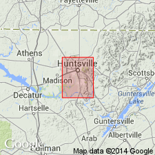
Tuscumbia (St. Louis). Tuscumbia limestone, a somewhat cherty limestone, 20 to 150 feet thick, occurring in immediate valley of Tennessee River from Huntsville westward. Overlies Lauderdale cherty limestone and underlies Mountain limestone. Is = to upper part of Fort Payne chert. Age is Mississippian.
Named from exposures at Tuscumbia, Colbert Co., northern AL.
Source: US geologic names lexicon (USGS Bull. 896, p. 2201).

- Usage in publication:
-
- Tuscumbia limestone*
- Modifications:
-
- Revised
- AAPG geologic province:
-
- Black Warrior basin
Summary:
Tuscumbia limestone, as defined in this report, applies to the limestones of AL that underlie Ste. Genevieve limestone, overlie Fort Payne chert (restricted), and include rocks corresponding to only St. Louis, Spergen, and Warsaw limestones of Mississippi Valley section.
Source: GNU records (USGS DDS-6; Reston GNULEX).

- Usage in publication:
-
- Tuscumbia limestone*
- Modifications:
-
- Overview
- AAPG geologic province:
-
- Black Warrior basin
Summary:
Tuscumbia limestone as later defined by C. Butts (Alabama Geol. Survey Spec. Rpt., no. 14, 1926) applies to the limestones of Alabama that underlie Ste. Genevieve limestone, overlie Fort Payne chert (restricted), and include rocks corresponding to only St. Louis, Spergen, and Warsaw limestones of Mississippi Valley section. This is present definition of the USGS. (See also under Fort Payne chert.)
Source: US geologic names lexicon (USGS Bull. 896, p. 2201).
- Usage in publication:
-
- Tuscumbia limestone*
- Modifications:
-
- Overview
- AAPG geologic province:
-
- Black Warrior basin
Summary:
Limestone units of Warsaw and St. Louis age are herein considered as a unit, for which name Tuscumbia limestone is applied. Thickness about 200 ft. Overlies Fort Payne chert; underlies Ste. Genevieve limestone.
Source: GNU records (USGS DDS-6; Reston GNULEX).
- Usage in publication:
-
- Tuscumbia limestone*
- Modifications:
-
- Areal extent
- AAPG geologic province:
-
- Black Warrior basin
Summary:
In Murphree Valley anticline, Tuscumbia underlies Bangor limestone and overlies Fort Payne chert. Contains many lentils and thick beds of sandstone.
Source: GNU records (USGS DDS-6; Reston GNULEX).

- Usage in publication:
-
- Tuscumbia limestone
- Modifications:
-
- Overview
- AAPG geologic province:
-
- Black Warrior basin
Summary:
Tuscumbia described in Madison Co. where it is composed of about 150 to 200 ft of thin- to thick-bedded, gray, fine to coarsely crystalline, highly fossiliferous limestone with small amounts of gray to white chert occurring as irregular lenses and nodules. Includes rocks between Fort Payne chert and Ste. Genevieve limestone and is equivalent to St. Louis and Warsaw limestones of Mississippi Valley region.
Source: GNU records (USGS DDS-6; Reston GNULEX).
- Usage in publication:
-
- Tuscumbia Limestone
- Modifications:
-
- Areal extent
- Overview
- AAPG geologic province:
-
- Black Warrior basin
Summary:
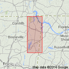
Tuscumbia first recognized in Tishomingo Co., MS, by Lowe (1915). Described by Welch (1958) at the surface and in the subsurface of northeastern MS and northwestern AL. In this report, local names of Morse (1928), Iuka Formation and Carmack Limestone, are dropped in favor of the more widely used terms Tuscumbia Limestone and Fort Payne Formation. In study area, Tuscumbia is a thick sequence of bioclastic (crinoidal), crystalline limestones, cherty limestones, and less frequent occurrences of chert. Color ranges from light to dark gray. Primarily composed of medium- to thick-bedded, medium-gray, bioclastic grainstone, wackestone, and mudstone. Thickness reaches a maximum of 240 ft in Blount Co., AL, and thins to 50 ft toward the center of the Black Warrior basin. In northwestern GA, it ranges from 115 to 213 ft. The Tuscumbia is continuous in the subsurface of Tishomingo Co., MS, and well data reflect a thickness of 240 ft. Formation is truncated by the Upper Cretaceous erosional surface at the base of the Tuscaloosa in southwestern Itawamba Co., MS. In study area, underlies the Pride Mountain Formation and overlies the Fort Payne Formation. Assignment to Iowa Group in this report follows the nomenclature and stratigraphic classification recognized by the Mississippi Bureau of Geology (Dockery, 1981). [Iowa is time-term and was never defined as rock-stratigraphic unit.]
Source: GNU records (USGS DDS-6; Reston GNULEX).
- Usage in publication:
-
- Tuscumbia Limestone
- Modifications:
-
- Biostratigraphic dating
- AAPG geologic province:
-
- Appalachian basin
Summary:
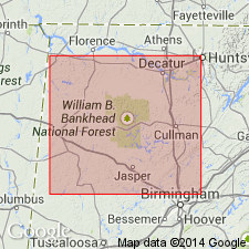
Presence of the conodonts CAVUSGNATHUS NAVICULUS (Hinde) and IDIOSPRIONIODUS Grunnel in the upper Tuscumbia at Hoover quarry, in Allsboro, and at the Vann quarry in Trussville, AL, indicates a Chesterian age. Therefore, the Meramecian-Chesterian boundary is within the uppermost Tuscumbia Limestone and does not coincide with the lithostratigraphic boundary of the Tuscumbia and Pride Mountain as previously thought. At the Asphalt Rock quarry, Tuscumbia, the chronostratigraphic boundary may occur 5 m above the lithostratigraphic boundary.
Source: GNU records (USGS DDS-6; Reston GNULEX).
For more information, please contact Nancy Stamm, Geologic Names Committee Secretary.
Asterisk (*) indicates published by U.S. Geological Survey authors.
"No current usage" (†) implies that a name has been abandoned or has fallen into disuse. Former usage and, if known, replacement name given in parentheses ( ).
Slash (/) indicates name conflicts with nomenclatural guidelines (CSN, 1933; ACSN, 1961, 1970; NACSN, 1983, 2005, 2021). May be explained within brackets ([ ]).