The National Geologic Map Database is migrating to a new infrastructure. We apologize for any service disruptions during this process.
|
|---|


- Usage in publication:
-
- Tunp Member*
- Modifications:
-
- Named
- Dominant lithology:
-
- Mudstone
- Diamictite
- AAPG geologic province:
-
- Green River basin
Summary:
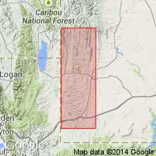
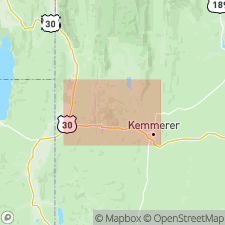
Named for exposures in Tunp Range, western Lincoln Co, WY in Greater Green River basin. Type area designated along Dempsey Ridge in Ts23, 24, and 25N, R118W. Exposed in a narrow belt around periphery of Fossil basin, as far north as T27N, R117W. Usually 100-200 ft thick. Exceeds 500 ft thick locally. Consists chiefly of dark-red to medium-red conglomeratic mudstone and blocky breccia in a mudstone matrix. Is an unsorted aggregate of small to large angular fragments, poorly rounded fragments, well-rounded pebbles to boulders to blocks of heterogeneous lithology (from Wells, Thaynes, Nugget, Twin Creek, and Preuss Formations) in an unsorted red sandy mudstone matrix. In some places mudstone fills spaces between packed fragments and blocks and forms half the bulk; in other places scattered pebbles, boulders, or blocks are dispersed in the mudstone. Is a diamictite. Is younger than basal conglomerate member of Wasatch and Sillem Member (new) of Fowkes Formation. Is equivalent to all of Wasatch of Fossil basin. Is unfossiliferous. Likely of early Eocene age. Stratigraphic chart. Geologic map.
Source: GNU records (USGS DDS-6; Denver GNULEX).
- Usage in publication:
-
- Tunp Member*
- Modifications:
-
- Overview
- AAPG geologic province:
-
- Green River basin
Summary:
Mapped (geologic map, cross sections) as a member of Wasatch Formation in west-central part of map area, Lincoln Co, WY, Greater Green River basin. All the exposures occur in a linear belt north of Twin Creek and around the Fossil basin. Is poorly exposed. Consists of unoriented angular blocks (some several hundred ft long) and boulders in unsorted pebbly to sandy red to maroon mudstone--a diamictite. Tongues of diamictite extend into Green River Formation and tongues grade into the mudstone tongue and Bullpen Member of Wasatch. Is several hundred ft thick. Is equivalent to the lower member, sandstone tongue, mudstone tongue, Bullpen Member, and main body of Wasatch to the east. Is younger than Evanston Formation and older than Sillem Member of Fowkes Formation. Eocene age.
Source: GNU records (USGS DDS-6; Denver GNULEX).
For more information, please contact Nancy Stamm, Geologic Names Committee Secretary.
Asterisk (*) indicates published by U.S. Geological Survey authors.
"No current usage" (†) implies that a name has been abandoned or has fallen into disuse. Former usage and, if known, replacement name given in parentheses ( ).
Slash (/) indicates name conflicts with nomenclatural guidelines (CSN, 1933; ACSN, 1961, 1970; NACSN, 1983, 2005, 2021). May be explained within brackets ([ ]).