

- Usage in publication:
-
- Tunnel Spring Tuff
- Modifications:
-
- Named
- Dominant lithology:
-
- Tuff
- AAPG geologic province:
-
- Great Basin province
Summary:
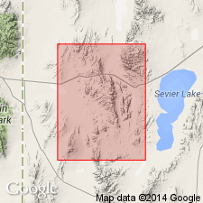
Named for Tunnel Spring Mountains, Millard Co, UT in Great Basin province. Type section designated in secs 23, 24, 25, and 26, T23N, R16W, Crystal Peak quad. Is exposed also in the Confusion Range, Wah Wah Mountains and Burbank Hills. Lies unconformably on Paleozoic sedimentary rocks [specific unit not stated]. Underlies conglomerate of Skull Rock Pass or at some localities, Cottonwood Wash Member of Needles Range Formation of Tertiary age. Consists of white, unsorted, nonwelded, friable ash-flow tuff that weathers in a "Swiss-cheese" fashion. White undeformed or unaltered pumice fragments 0.5 cm average diameter are abundant. Quartz, sanidine, plagioclase, and biotite phenocrysts make up 27 percent of the tuff. Matrix is composed of angular, glassy, slightly devitrified fragments. Bedding noted at several localities. Is 350 m thick at Crystal Peak. Thickest section 570 m is at Cowboy Pass. Dates of 33.7 +/-0.7 m.y. (K-Ar) and 32.7 +/-1.3 m.y. at Crystal Peak, and 30.9 +/-1.2 m.y. at North Canyon. Considered a volcaniclastic rock by the abundance of pumice fragments in a matrix of glass shards and crystals of the same composition.
Source: GNU records (USGS DDS-6; Denver GNULEX).
- Usage in publication:
-
- Tunnel Spring Tuff*
- Modifications:
-
- Adopted
- AAPG geologic province:
-
- Great Basin province
Summary:
Tunnel Spring Tuff of Bushman (1973) is adopted. Age is Tertiary.
Source: GNU records (USGS DDS-6; Menlo GNULEX).
- Usage in publication:
-
- Tunnel Spring Tuff*
- Modifications:
-
- Age modified
- AAPG geologic province:
-
- Great Basin province
Summary:
Age of the Tunnel Spring Tuff is Oligocene.
Source: GNU records (USGS DDS-6; Menlo GNULEX).
- Usage in publication:
-
- Tunnel Spring Tuff*
- Modifications:
-
- Overview
- AAPG geologic province:
-
- Great Basin province
Summary:
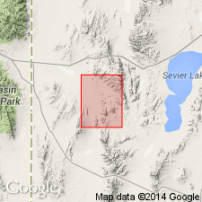
Deposited over Paleozoic sedimentary rocks in an area of 16 km by 10 km across east of Crystal Peak, Millard Co, UT, Great Basin province. Resulted from a series of violent pyroclastic eruptions in early Oligocene time. Date (K-Ar) of 35.4 Ma obtained during this study. Source area, Crystal Peak, disappeared by Cottonwood Wash time. Succeeded by Cottonwood Wash Tuff and Wah Wah Springs Formation. Tunnel Spring is 400+ m thick at Crystal Peak. Small scraps of the formation mapped as far as 25 km east and 15 to 25 km west and southwest of the Peak. At most localities, the tuff does not exceed a few tens of m thick, but at Cowboy Pass a section 570 m thick has been reported. Lower part of Tunnel Spring which makes up Crystal Peak and scattered remnants to west is a massive slightly to nonwelded rhyolite ash-flow tuff with 27 percent phenocrysts of doubly terminated quartz crystals, glassy feldspar tablets, and sparse biotite flakes in a white glassy ash matrix. Foreign sedimentary rock fragments make up 10-40 percent of the rock; small gravel size in west exposures and angular fragments in eastern exposures. East-northeast of Crystal Peak formation divisible into a basal massive, pumice-rich, nonwelded rhyolite with abundant phenocrysts and an upper bedded massive, pink to white, poorly welded ash-flow tuff with few quartz and feldspar phenocrysts.
Source: GNU records (USGS DDS-6; Denver GNULEX).
For more information, please contact Nancy Stamm, Geologic Names Committee Secretary.
Asterisk (*) indicates published by U.S. Geological Survey authors.
"No current usage" (†) implies that a name has been abandoned or has fallen into disuse. Former usage and, if known, replacement name given in parentheses ( ).
Slash (/) indicates name conflicts with nomenclatural guidelines (CSN, 1933; ACSN, 1961, 1970; NACSN, 1983, 2005, 2021). May be explained within brackets ([ ]).