The National Geologic Map Database is migrating to a new infrastructure. We apologize for any service disruptions during this process.
|
|---|


- Usage in publication:
-
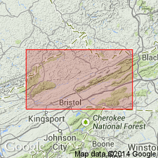
- Tumbez limestone
- Modifications:
-
- Named
- Dominant lithology:
-
- Limestone
- AAPG geologic province:
-
- Appalachian basin
Summary:
Named the Tumbez limestone for Tumbez, Russell Co., southwestern VA. Name was proposed for limestone equivalent to the typical Blackford formation in Russell Co.; shaly dolomitic beds of the Blackford are replaced by predominantly coarse-grained limestone of the Tumbez. Interbedded lithologies are exposed at the type locality. Thickness of the Tumbez is 120 feet. Unit overlies the "Knox" dolomite and underlies the Elway limestone. The Tumbez is of Middle Ordovician age.
Source: GNU records (USGS DDS-6; Reston GNULEX).
- Usage in publication:
-
- Tumbez Formation
- Modifications:
-
- Areal extent
- Revised
- AAPG geologic province:
-
- Appalachian basin
Summary:
Geographically extended the Tumbez to eastern TN and revised it to the Tumbez Formation. Lithology is mentioned to be a lime-sand.
Source: GNU records (USGS DDS-6; Reston GNULEX).
For more information, please contact Nancy Stamm, Geologic Names Committee Secretary.
Asterisk (*) indicates published by U.S. Geological Survey authors.
"No current usage" (†) implies that a name has been abandoned or has fallen into disuse. Former usage and, if known, replacement name given in parentheses ( ).
Slash (/) indicates name conflicts with nomenclatural guidelines (CSN, 1933; ACSN, 1961, 1970; NACSN, 1983, 2005, 2021). May be explained within brackets ([ ]).