

- Usage in publication:
-
- Trusty Gulch Volcanics*
- Modifications:
-
- Named
- Dominant lithology:
-
- Andesite
- Dacite
- Rhyodacite
- AAPG geologic province:
-
- Montana folded belt
Summary:
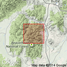
Named for exposures on slopes north of Trusty Gulch, northeast of Vipond Park quad, Beaverhead Co, MT in the Montana folded belt province. These exposures designated the type section. Is composed of flows and flow breccias ranging from basaltic andesite through andesite, dacite to rhyodacite. No volcanic center known; extruded on land. Has whole rock K-Ar ages of 45.6 +/-1.6 to 49.9 +/-1.7 m.y., or Eocene.
Source: GNU records (USGS DDS-6; Denver GNULEX).
For more information, please contact Nancy Stamm, Geologic Names Committee Secretary.
Asterisk (*) indicates published by U.S. Geological Survey authors.
"No current usage" (†) implies that a name has been abandoned or has fallen into disuse. Former usage and, if known, replacement name given in parentheses ( ).
Slash (/) indicates name conflicts with nomenclatural guidelines (CSN, 1933; ACSN, 1961, 1970; NACSN, 1983, 2005, 2021). May be explained within brackets ([ ]).