The National Geologic Map Database is migrating to a new infrastructure. We apologize for any service disruptions during this process.
|
|---|


- Usage in publication:
-
- Tripon Pass Limestone
- Modifications:
-
- Named
- Dominant lithology:
-
- Limestone
- AAPG geologic province:
-
- Great Basin province
Summary:
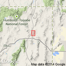
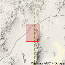
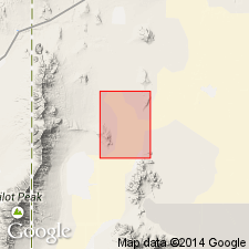
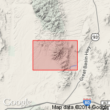
Named for exposures, designated the type section, 1.25 mi south of Tripon Pass, Wine Cup Ranch SW quad, Elko Co, NV in the Great Basin province. Tripon Pass, the geographic feature, is in N1/2 sec 22, T39N, R64E. Disconformably overlies Guilmette Formation. Underlies Diamond Peak Formation. Map shows distribution of formation in the Windermere Hills of NV where two types of limestone mapped --a thin- to medium-bedded type and a medium- to thick-bedded type. The formation is allochthonous. Consists of 1,550 ft of clastic limestone and interbedded black argillite, buff quartz siltite, arenite, and gray to brown quartz-chert arenite. Lower 550 ft is thin- to medium-bedded slabby, dark gray, argillaceous limestone that weathers pale gray, buff, pink. The overlying 250 ft are medium- to thick-bedded slabby and blocky calcirudite with platy calcisiltite and calcarenite interbeds. Carbonate clasts mostly 5 cm across, some are 30 cm in basal parts of crudely graded beds. These beds have flutes and grooves deformed by loading suggesting turbidity currents. The upper 750 ft of the Tripon Pass is similar to the lower part except for increased number of argillite interbeds. Quartz-chert arenite more common near upper contact. Conodonts collected at 6 different levels in the formation. Local occurrences of crinoid fragments and stromatolites. Siphonodellids accompanied by GNATHODUS PUNCTATUS at level 1,524 ft above base indicate Kinderhookian age. Presence of SIPHONODELLA OBSOLETA about 20 ft above base indicates formation is no older than Kinderhookian. These rocks were previously unnamed.
Source: GNU records (USGS DDS-6; Denver GNULEX).
- Usage in publication:
-
- Tripon Pass Limestone*
- Modifications:
-
- Adopted
- AAPG geologic province:
-
- Great Basin province
Summary:
Tripon Pass Limestone of Oversby (1973) is adopted. Age is Early Mississippian.
Source: GNU records (USGS DDS-6; Menlo GNULEX).
- Usage in publication:
-
- Tripon Pass Limestone*
- Modifications:
-
- Overview
- Areal extent
- AAPG geologic province:
-
- Great Basin province
Summary:
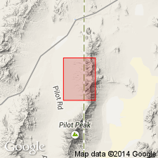
A dark gray to black, regularly bedded, silty limestone and subordinate interbeds of calcareous siltstone that weathers pinkish gray forms rounded grassy slopes covered by gray, fissile to platy cleared limestone fragments. Some cliffy exposures. Worm burrows, crinoids, bryozoan fragments present locally. Some rusty-colored sand-bearing laminae. Brown chert nodules locally near top. Tectonically overlies Devonian Guilmette Formation. Rarely more than 10 m thick in quad. Is 400 m thick 3 km to south of quad. Temporally equivalent to Joana Limestone of Pequop Mountains to west. Mapped in southeast part of quadrangle, Box Elder Co, UT, Great Basin province. In fault contact with the Mississippian Chainman Shale and Diamond Peak Formation undivided. Of Mississippian age. [Also mapped in Lucin quad which joins this area on the east in Utah Geological and Mineral Survey Map 78 by D. M. Miller.]
Source: GNU records (USGS DDS-6; Denver GNULEX).
- Usage in publication:
-
- Tripon Pass Limestone*
- Modifications:
-
- Overview
- AAPG geologic province:
-
- Great Basin province
Summary:
Mapped in small exposures in Little Pigeon Mountains in northeast part of quad, Box Elder Co, UT in the Great Basin province. Disconformably underlies Strathearn? Formation. Consists mostly of thin-bedded, black, silty limestone and rare thick limestone beds with abundant crinoidal debris. Trace fossil PHYCOSIPHON found in silty limestone. Conodonts (listed) in silty limestone 7 ft below top and from limestone 50 ft below top. The thick limestone beds of crinoidal debris in Little Pigeon Mountains are absent in Pilot Range, NV; these beds may be tongues of Joana Limestone. Mississippian age.
Source: GNU records (USGS DDS-6; Denver GNULEX).
- Usage in publication:
-
- Tripon Pass Limestone*
- Modifications:
-
- Areal extent
- AAPG geologic province:
-
- Great Basin province
Summary:
Tripon Pass Limestone is geographically extended into the report area. Age is Early Mississippian.
Source: GNU records (USGS DDS-6; Menlo GNULEX).
- Usage in publication:
-
- Tripon Pass Limestone*
- Modifications:
-
- Areal extent
- AAPG geologic province:
-
- Great Basin province
Summary:
Tripon Pass Limestone is geographically extended into the report area. Age is Mississippian.
Source: GNU records (USGS DDS-6; Menlo GNULEX).
For more information, please contact Nancy Stamm, Geologic Names Committee Secretary.
Asterisk (*) indicates published by U.S. Geological Survey authors.
"No current usage" (†) implies that a name has been abandoned or has fallen into disuse. Former usage and, if known, replacement name given in parentheses ( ).
Slash (/) indicates name conflicts with nomenclatural guidelines (CSN, 1933; ACSN, 1961, 1970; NACSN, 1983, 2005, 2021). May be explained within brackets ([ ]).