The National Geologic Map Database is migrating to a new infrastructure. We apologize for any service disruptions during this process.
|
|---|


- Usage in publication:
-
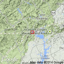
- Toxaway Gneiss
- Modifications:
-
- Named
- Dominant lithology:
-
- Gneiss
- AAPG geologic province:
-
- Piedmont-Blue Ridge province
Summary:
Named Toxaway Gneiss for the Toxaway River, Transylvania Co., NC. Unit is a granitic to quartz monzonitic gneiss. It is banded and forms the core of the Toxaway structural dome and shows repeating folding events. The Toxaway was previously called the Whiteside Granite. The base is not exposed; unconformably underlies the Tallulah Falls Formation.
Source: GNU records (USGS DDS-6; Reston GNULEX).
- Usage in publication:
-
- Toxaway Gneiss
- Modifications:
-
- Geochronologic dating
- AAPG geologic province:
-
- Piedmont-Blue Ridge province
Summary:
The Toxaway Gneiss of Hatcher (1974) has Rb-Sr whole-rock isochron age of 1109 +/-59 Ma (Fullagar and others, 1979).
Source: GNU records (USGS DDS-6; Reston GNULEX).
- Usage in publication:
-
- Toxaway Gneiss*
- Modifications:
-
- Overview
- Areal extent
- Geochronologic dating
- AAPG geologic province:
-
- Piedmont-Blue Ridge province
Summary:
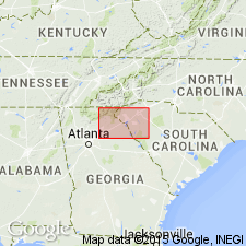
Toxaway Gneiss extended to GA. Described as light- to medium-gray, massive to well-layered, equigranular to inequigranular gneiss, characterized by coarse eyes or knots of quartz and feldspar enclosed by folia of medium-grained biotite; microcline commonly occurs as coarse, blocky porphyroblasts. Fullagar and others (1979) report a whole-rock age of 1203 +/-54 m.y. Age is Middle Proterozoic.
Source: GNU records (USGS DDS-6; Reston GNULEX).
For more information, please contact Nancy Stamm, Geologic Names Committee Secretary.
Asterisk (*) indicates published by U.S. Geological Survey authors.
"No current usage" (†) implies that a name has been abandoned or has fallen into disuse. Former usage and, if known, replacement name given in parentheses ( ).
Slash (/) indicates name conflicts with nomenclatural guidelines (CSN, 1933; ACSN, 1961, 1970; NACSN, 1983, 2005, 2021). May be explained within brackets ([ ]).