The National Geologic Map Database is migrating to a new infrastructure. We apologize for any service disruptions during this process.
|
|---|


- Usage in publication:
-
- Tomahawk Creek Formation*
- Modifications:
-
- Named
- Dominant lithology:
-
- Graywacke
- Phyllite
- AAPG geologic province:
-
- Piedmont-Blue Ridge province
Summary:
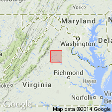
Named for Tomahawk Creek, south of Orange, Orange Co., central VA. Occurs in a small fault block immediately south of Orange. Was informally used by Pavlides (1990; USGS Open-File Report 90-548). Consists of green graywacke and phyllite. Thickness ranges from 0 to 300 m. Upper and lower contacts not exposed; may rest unconformably on Late Proterozoic Catoctin Formation and may be unconformably overlain by Cambrian(?) Nasons Formation (new). Only know correlative along strike to the southwest is, in part, BRA unit of Rossman (1991). Age is therefore assigned as Late Proterozoic(?) or Cambrian(?). Report includes geologic map and correlation chart.
Source: GNU records (USGS DDS-6; Reston GNULEX).
For more information, please contact Nancy Stamm, Geologic Names Committee Secretary.
Asterisk (*) indicates published by U.S. Geological Survey authors.
"No current usage" (†) implies that a name has been abandoned or has fallen into disuse. Former usage and, if known, replacement name given in parentheses ( ).
Slash (/) indicates name conflicts with nomenclatural guidelines (CSN, 1933; ACSN, 1961, 1970; NACSN, 1983, 2005, 2021). May be explained within brackets ([ ]).