

- Usage in publication:
-
- Tolstoi Formation
- Modifications:
-
- Named
- Dominant lithology:
-
- Volcaniclastics
- Breccia
- AAPG geologic province:
-
- Alaska Peninsula province
- Alaska Southwestern region
Summary:
Pt. 1, p. 83-85, 98-99, 101-102; Pt. 2, maps. Tolstoi Formation of Beaver Bay Group. Name applied to sequence of black siltstones with interbedded volcanic sandstones and conglomerates, flows, sills, and volcanic breccias southwest of Wide Bay. Thickness about 5,000 feet in Beaver Bay area. Overlies Upper Cretaceous Hoodoo Formation (new). Conformably underlies Stepovak Formation of Beaver Bay Group. Gradational contact between these two units often difficult to place, even within 500 to 1,000 feet of strata. Where these units cannot reasonably be separated from each other, or where Tolstoi Formation cannot be recognized with confidence, whole Paleocene sequence is mapped as Beaver Bay Group. Conformably underlies Meshik Formation in Chignik Bay area. Rocks have yielded Paleocene plants and middle Eocene marine invertebrates.
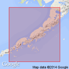
Type locality: along east shore of Pavlof Bay, north of Cape Tolstoi and Tolstoi Peak northward to entrance to Canoe Bay, Alaska Peninsula, southwestern AK. Not definitely known to be present southwest of type locality. Traced northeast of Pavlof Bay for 50 mi to head of Port Moller.
Source: US geologic names lexicon (USGS Bull. 1350, p. 764); supplemental information from GNU records (USGS DDS-6; Menlo GNULEX).
- Usage in publication:
-
- Tolstoi Formation*
- Modifications:
-
- Adopted
- Biostratigraphic dating
- AAPG geologic province:
-
- Alaska Peninsula province
- Alaska Southwestern region
Summary:
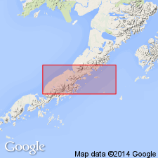
Tolstoi Formation (Burk, 1965) herein adopted. [however not mapped as part of Burk's Beaver Bay Group]. In mapped area includes all sedimentary rocks unconformably above Hoodoo Formation and unconformably below Meshik Formation. Plant fossils (J.A. Wolfe, oral commun., 1979) indicate unit in mapped area is of Paleocene and Eocene age.
Source: GNU records (USGS DDS-6; Menlo GNULEX).
- Usage in publication:
-
- Tolstoi Formation*
- Modifications:
-
- Age modified
- AAPG geologic province:
-
- Alaska Peninsula province
- Alaska Southwestern region
Summary:
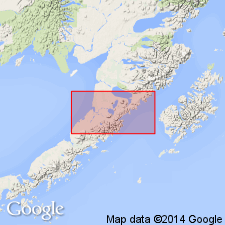
Abundant megaflora indicate that beds of Tolstoi Formation in southern part of Ugashik, Bristol Bay and part of Karluk quads are mainly early Eocene age. [overall unit age remains Paleocene and Eocene.]
Source: GNU records (USGS DDS-6; Menlo GNULEX).
- Usage in publication:
-
- Tolstoi Formation*
- Modifications:
-
- Reference
- Biostratigraphic dating
- AAPG geologic province:
-
- Alaska Peninsula province
- Alaska Southwestern region
Summary:
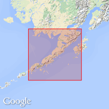
Tolstoi Formation. Detailed measured section (644 m thick) is designated type section; located along east shore of Pavlof Bay between Tolstoi Peak and Lone Peak in Port Moller B-5 and C-5 quadrangles (scale 1:63,360), Alaska Peninsula, southwestern Alaska. Reference section (1375 m thick) designated at Ivanof Bay, Stepovak Bay B-5 quadrangle (scale 1:63,360), Alaska Peninsula, southwestern Alaska. Age is late Paleocene to middle Eocene based on fauna and flora. [discussion included]
Source: Modified from GNU records (USGS DDS-6; Menlo GNULEX).
For more information, please contact Nancy Stamm, Geologic Names Committee Secretary.
Asterisk (*) indicates published by U.S. Geological Survey authors.
"No current usage" (†) implies that a name has been abandoned or has fallen into disuse. Former usage and, if known, replacement name given in parentheses ( ).
Slash (/) indicates name conflicts with nomenclatural guidelines (CSN, 1933; ACSN, 1961, 1970; NACSN, 1983, 2005, 2021). May be explained within brackets ([ ]).