

- Usage in publication:
-
- Toll Gate Olivine Basalt
- Modifications:
-
- Named
- Dominant lithology:
-
- Basalt
- AAPG geologic province:
-
- Snake River basin
Summary:
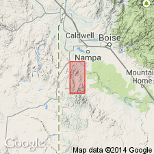
Named for typical exposures at Toll Gate, near center sec 24 T3S, R4W, Owyhee Co, ID, Snake River basin, and for 1 mi upstream from that area along Reynolds Creek. Is one of eight units in Reynolds Basin Group (new); group is an intertonguing sequence of olivine basalt flows, silicic tuff, diatomite, arkosic sands and gravels, and felsitic to glassy flows of latite--group is late Miocene or early Pliocene. Toll Gate forms dark, blocky, rubbly slopes or low, dark, columnar ledges over most of outcrop area. Usually underlain by an altered basalt lapilli tuff or tuff-breccia. Shows well-defined zones in Toll Gate area (where at least 70 ft thick) characterized by pronounced changes in jointing types. Lower 30 ft (base not exposed) has undulatory vertical prismatic jointing spaced 1-3 ft apart; grades upward rapidly into a zone of irregular blockiness, about 15 ft thick, with joints spaced 2-6 in apart; grades upward to a zone 20-25 ft thick of crudely formed prismatic joints spaced 2-4 ft apart--lower 10 ft of this zone locally shows secondary jointing. Upper 5-7 ft is vesicular (indicating nearness to top of flow). Is single, undivided basalt flow in spite of big textural differences from zone to zone. Fresh rock mostly dark gray to grayish black, dense, nonporphyritic; some outcrops strongly magnetic. Also has a coarsely porphyritic flow containing discs of labradorite. Because eroded greatly, distribution not clearly known.
Source: GNU records (USGS DDS-6; Denver GNULEX).
- Usage in publication:
-
- Toll Gate Basalt*
- Modifications:
-
- Geochronologic dating
- AAPG geologic province:
-
- Snake River basin
Summary:
Pg. 11, geologic time scale (inside front cover). Toll Gate Basalt (McIntyre, 1972). Sample from a very fine-grained, intersertal, non-porphyritic basalt composed of plagioclase, clinopyroxene, opaques, and minor interstitial brown glass. Collected in blasted exposure, Lat. 43 deg. 04 min. 04 sec. N., Long. 116 deg. 45 min. 03 sec. W., in NE/4 sec. 24, T. 4 S., R. 4 W., Rooster Comb 15-min quadrangle, Owyhee County, Idaho. K-Ar age on whole-rock 9.4 +/-0.3 Ma; calculated age is minimum age for the basalt. Decay constants of Steiger and Jager, 1977 (Earth Planet. Sci. Letters, v. 36, p. 359-362) are used. [Age considered Miocene (from Geologic Names Committee, USGS, 1983 ed. geol. time scale, with additions from N.J. Snelling, 1985, The Geol. Soc. Mem., no. 10).]
Source: Publication.
For more information, please contact Nancy Stamm, Geologic Names Committee Secretary.
Asterisk (*) indicates published by U.S. Geological Survey authors.
"No current usage" (†) implies that a name has been abandoned or has fallen into disuse. Former usage and, if known, replacement name given in parentheses ( ).
Slash (/) indicates name conflicts with nomenclatural guidelines (CSN, 1933; ACSN, 1961, 1970; NACSN, 1983, 2005, 2021). May be explained within brackets ([ ]).