The National Geologic Map Database is migrating to a new infrastructure. We apologize for any service disruptions during this process.
|
|---|


- Usage in publication:
-
- Tillman metasedimentary group
- Modifications:
-
- First used
- Dominant lithology:
-
- Graywacke
- Argillite
- Quartzite
- Chert
- AAPG geologic province:
-
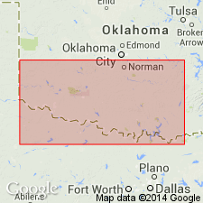
- Palo Duro basin
- South Oklahoma folded belt
Summary:
First used; intent to name not stated, and no type locality designated. Origin of name not stated. Report area is southern Oklahoma, where it is present in: Cotton Co (South Oklahoma folded belt province); and Tillman and Jackson Cos (Palo Duro basin). Consists of low-rank meta-graywacke, argillite, quartzite, and bedded chert in a subsurface sequence probably at least 15,000 ft thick, representing marine eugeosynclinal deposits in the first stage of filling of the southern Oklahoma geosyncline. Graywackes are converted into hornfels and biotite schist near intrusive contacts with Wichita Granite Group (revised). Includes Meers Quartzite of outcrop, which occurs as inclusions in gabbro and granite. Is younger than the extrusive Navajoe Mountain Basalt-Spilite Group and its intrusive equivalent, Raggedy Mountain Gabbro Group (both new, of Early Cambrian? age). Age is shown to be Late Precambrian or Early Cambrian (>550). Geologic map. Generalized sections.
Source: GNU records (USGS DDS-6; Denver GNULEX).
- Usage in publication:
-
- Tillman Metasedimentary Group
- Modifications:
-
- Named
- Dominant lithology:
-
- Graywacke
- Argillite
- Quartzite
- Chert
- AAPG geologic province:
-
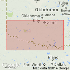
- Palo Duro basin
- South Oklahoma folded belt
Summary:
Named for Tillman Co, OK where unit has been penetrated in subsurface by many wells. Type not designated. Occurs over an area of 1350 sq mi in subsurface south of Wichita Mountains as defined by drilling in Tillman and Jackson Cos, Palo Duro basin and Cotton Co, S. Oklahoma folded belt province. Probably also present between Wichita Mountains and eastern part of Arbuckle Mountains, though due to great depth has not yet been drilled. Meers Quartzite (revised) is included in Tillman; Meers has not been encountered by drilling but is known as inclusions in Raggedy Mountain Gabbro Group and in Wichita Granite Group at several outcrops in Wichita Mountains. Consists mostly of metagraywacke and argillite; chert and strongly metamorphosed quartzite of the Meers; less abundant are schists and hornfels. Deepest penetration in Tillman is 325 ft. Original rocks of Tillman were graywacke interbedded with shale and sandstone, and locally, bedded chert. Petrographic information; descriptions from wells. Older than Navajoe Mountain Basalt-Spilite Group (new) and Raggedy Mountain Gabbro Group (new); younger than unnamed Precambrian granites in Eastern Arbuckle Province. Probably Early Cambrian age.
Source: GNU records (USGS DDS-6; Denver GNULEX).
- Usage in publication:
-
- Tillman Metasedimentary Group
- Modifications:
-
- Overview
- AAPG geologic province:
-
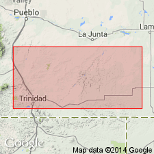
- South Oklahoma folded belt
Summary:
Thought to correlate with newly named Las Animas Formation of Las Animas Co., CO in Las Vegas-Raton basin. Both units are probably the same age (Proterozoic Y), of similar character (moderately metamorphosed graywacke, pelitic rocks, and chert), and occurrence (deposited in a deep west-northwest trough of rift origin). [Tillman occurs in Wichita Mountains, OK, South Oklahoma folded belt province.]
Source: GNU records (USGS DDS-6; Denver GNULEX).
For more information, please contact Nancy Stamm, Geologic Names Committee Secretary.
Asterisk (*) indicates published by U.S. Geological Survey authors.
"No current usage" (†) implies that a name has been abandoned or has fallen into disuse. Former usage and, if known, replacement name given in parentheses ( ).
Slash (/) indicates name conflicts with nomenclatural guidelines (CSN, 1933; ACSN, 1961, 1970; NACSN, 1983, 2005, 2021). May be explained within brackets ([ ]).