

- Usage in publication:
-
- Thumb formation*
- Modifications:
-
- Named
- AAPG geologic province:
-
- Great Basin province
Summary:
Unit is named the Thumb Formation. Age is Cretaceous(?).
Source: GNU records (USGS DDS-6; Menlo GNULEX).
- Usage in publication:
-
- Thumb formation*
- Modifications:
-
- Named
- Dominant lithology:
-
- Conglomerate
- Sandstone
- Siltstone
- Limestone
- Breccia
- AAPG geologic province:
-
- Great Basin province
Summary:
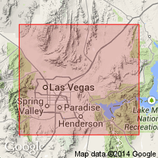
Named for Thumb valley, a tributary to Las Vegas Wash about 4 mi southeast of Frenchman Mountain, Clark Co, NV in the Great Basin province. Mapped (geologic map) in northwesternmost part of area in and just south of Thumb valley. Type section designated in Thumb valley where it unconformably (angular) overlies Triassic Chinle formation and is separated from the Horse Spring formation by an erosional unconformity. Is 2,580 to 2,930 ft thick at type. Consists of basal conglomerate derived from older formations in the area succeeded in sequence by: 1) red-brown sandstone and siltstone with conglomerate and limestone lenses; 2) gray to yellow thin-bedded limestone; 3) yellow, fine-grained sandstone with some bedded gypsum and gypsiferous clay; 4) coarse conglomerate; 5) red-brown sandstone and siltstone and thick conglomerate lenses; 6) brown sandstone, gypsiferous siltstone and claystone, and some basaltic lava; 7) coarse breccia of Precambrian metamorphic and granitic rock fragments. No fossils found. Tentatively assigned a Cretaceous? age.
Source: GNU records (USGS DDS-6; Denver GNULEX).

- Usage in publication:
-
- Thumb Member*
- Modifications:
-
- Principal reference
- Revised
- Geochronologic dating
- AAPG geologic province:
-
- Great Basin province
Summary:
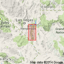
Formerly of formation rank; included rocks at base that are reassigned as basal member of Horse Spring Formation in this report. Was named for Thumb Valley, term no longer shown on topographic maps. Geographic name retained because of historical use, and applied to rocks in Horse Spring Formation above Rainbow Gardens Member (named) and below Bitter Ridge Limestone Member (named). Occurs in scattered outcrops (areal extent map) from Virgin Mountains west to Frenchman Mountain, Clark Co, NV, Great Basin province. May be as much as 1300 m thick in unfaulted sections. Principal reference section designated (but not described) in Rainbow Gardens area at about 36 deg 07' 30" N lat, 114 deg 56' 45" W long, Henderson and Frenchman Mountain quads. Consists: 1) sandstone (predominant lithology)--medium to very fine grained, mostly fine, some coarse grained, brown, parallel bedded; 2) conglomerate of carbonate, chert, gneiss, granite, mafic rocks, volcanic rocks, sandstone clasts whose content varies dependent on locality (facies map) and occurs as discontinuous uneven, nonuniform beds; 3) breccia in unstratified unsorted lenses; 4) gypsum as white to dark gray wavy, continuous uniform beds; 5) locally, limestone that is hard, fine grained, resistant, yellow and gray; 6) green hornblende biotite tuff interbedded with conglomerate. Has lacustrine and alluvial facies rocks. Yielded ages 15.6-12.5 m.y. Paleogeologic map. Stratigraphic diagram.
Source: GNU records (USGS DDS-6; Denver GNULEX).
- Usage in publication:
-
- Thumb Member*
- Modifications:
-
- Age modified
- AAPG geologic province:
-
- Great Basin province
Summary:
Age of the Thumb Member of the Horse Spring Formation is everywhere revised from Miocene to: middle Miocene based on radiometric age range of 18 to approximately 14 Ma.
Source: GNU records (USGS DDS-6; Menlo GNULEX).
For more information, please contact Nancy Stamm, Geologic Names Committee Secretary.
Asterisk (*) indicates published by U.S. Geological Survey authors.
"No current usage" (†) implies that a name has been abandoned or has fallen into disuse. Former usage and, if known, replacement name given in parentheses ( ).
Slash (/) indicates name conflicts with nomenclatural guidelines (CSN, 1933; ACSN, 1961, 1970; NACSN, 1983, 2005, 2021). May be explained within brackets ([ ]).