

- Usage in publication:
-
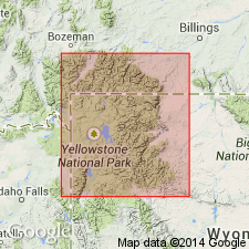
- Thorofare Creek Group*
- Modifications:
-
- Named
- Geochronologic dating
- Dominant lithology:
-
- Volcaniclastics
- Andesite
- AAPG geologic province:
-
- Yellowstone province
Summary:
Named as the youngest group of Absaroka Volcanic Supergroup (new) for region of Thorofare Creek (the type area), near the southeast corner of Yellowstone National Park, Yellowstone province, WY. Divided into (oldest to youngest): Langford, and its Promontory Member (both new), Two Ocean (new), Tepee Trail, and Wiggins Formations that total more than 6,000 ft thick. Consists of volcaniclastic rocks. Is younger than Sunlight Group. Intertongues with Trout Peak Trachyandesite. Radiometric dates (44-49 m.y.), sparse flora and fauna indicate a middle Eocene to possibly late Eocene age.
Source: GNU records (USGS DDS-6; Denver GNULEX).
For more information, please contact Nancy Stamm, Geologic Names Committee Secretary.
Asterisk (*) indicates published by U.S. Geological Survey authors.
"No current usage" (†) implies that a name has been abandoned or has fallen into disuse. Former usage and, if known, replacement name given in parentheses ( ).
Slash (/) indicates name conflicts with nomenclatural guidelines (CSN, 1933; ACSN, 1961, 1970; NACSN, 1983, 2005, 2021). May be explained within brackets ([ ]).