

- Usage in publication:
-
- Thatcher Limestone Member*
- Modifications:
-
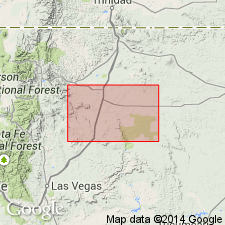
- Areal extent
- AAPG geologic province:
-
- Las Vegas-Raton basin
- Sierra Grande uplift
Summary:
Areally extended (not mapped) to northeast NM, in Colfax Co in Las Vegas-Raton basin and in Harding Co on Sierra Grande uplift, as a member of Graneros Shale. Lies a few ft above base of formation. Is of Late Cretaceous age (fossiliferous).
Source: GNU records (USGS DDS-6; Denver GNULEX).
For more information, please contact Nancy Stamm, Geologic Names Committee Secretary.
Asterisk (*) indicates published by U.S. Geological Survey authors.
"No current usage" (†) implies that a name has been abandoned or has fallen into disuse. Former usage and, if known, replacement name given in parentheses ( ).
Slash (/) indicates name conflicts with nomenclatural guidelines (CSN, 1933; ACSN, 1961, 1970; NACSN, 1983, 2005, 2021). May be explained within brackets ([ ]).