The National Geologic Map Database is migrating to a new infrastructure. We apologize for any service disruptions during this process.
|
|---|


- Usage in publication:
-
- Tehama formation
- Modifications:
-
- Original reference
- AAPG geologic province:
-
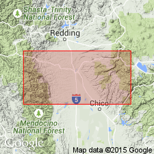
- Sacramento basin
Summary:
Tehama formation. Name proposed by Mr. Russell. Consists of 2,000+/- feet of massive pale greenish-gray to pale-buff sandy clays, which are usually tuffaceous. Intercalations of sand and gravel, often strongly cross-bedded, are present throughout. A massive coarse-grained pumice tuff member (for which C.A. Anderson and R.D. Russell propose name Nomlaki tuff member) occurs near base. This same tuff member occurs near base of Tuscan formation, so that the two formations must be in part contemporaneous, and they in fact interfinger, but their conditions of deposition are in general dissimilar. The Tehama consists of flood-plain deposits laid down on a comparatively low-lying land surface, while the Tuscan is largely composed of agglomerates, presumably mud flows. The Tuscan formation is almost exclusively andesitic material derived from old volcanoes in Lassen region; the Tehama, with exception of Nomlaki tuff member, contains only a very subordinate amount of volcanic debris. The Tuscan formation extends along eastern border ot Sacramento Valley from Pentz northward almost to Pit River and east into Lassen Peak region. The Tehama formation occurs on western side of Sacramento Valley. The Tehama formation lies, with unconformity and overlap, on Cretaceous Chico-Shasta series, and is overlain disconformably, and locally with angular unconformity, by Red Bluff formation (Pleistocene). Named for outcrops in Tehama County, northern California. Stratigraphic evidence indicates Tehama and Tuscan formations are probably Pliocene. Vertebrate evidence (from above Nomlaki tuff member) indicates that both are upper Middle to Upper Pliocene.
Source: US geologic names lexicon (USGS Bull. 896, p. 2123).
- Usage in publication:
-
- Tehama formation*
- Modifications:
-
- Areal extent
- AAPG geologic province:
-
- Sacramento basin
Summary:
Pg. 232-235, pl. 3. Tehama formation. Consists of silts, silty clays, sands, and gravels, predominantly pale and yellowish to greenish gray, weathering pale buff to yellow brown. Nomlaki tuff member at base. Thickness more than 2,000 feet in central part of Pliocene valley in which it accumulated, with Nomlaki tuff about 700 feet from base. Contemporaneous with Tuscan formation and interfingers with it in their zone of junction. Capped By Red Bluff gravels.
Source: US geologic names lexicon (USGS Bull. 1200, p. 3839).
For more information, please contact Nancy Stamm, Geologic Names Committee Secretary.
Asterisk (*) indicates published by U.S. Geological Survey authors.
"No current usage" (†) implies that a name has been abandoned or has fallen into disuse. Former usage and, if known, replacement name given in parentheses ( ).
Slash (/) indicates name conflicts with nomenclatural guidelines (CSN, 1933; ACSN, 1961, 1970; NACSN, 1983, 2005, 2021). May be explained within brackets ([ ]).