

- Usage in publication:
-
- Teewinot formation*
- Modifications:
-
- Named
- Dominant lithology:
-
- Conglomerate
- Sandstone
- Claystone
- Limestone
- AAPG geologic province:
-
- Yellowstone province
Summary:
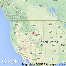
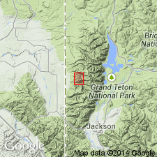
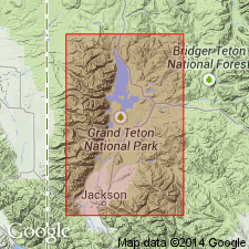
Named for Mt. Teewinot, northeast of Grand Teton, Teton Co, WY in Yellowstone province. Type section is in T42N, R115W and sec 36, T42N, R116W. Areal distribution shown on map. Total thickness not determined but is at least 5,000 and may be more. About 4,000 ft measured. Divisible into a basal conglomerate 1,400 ft thick that is interbedded with sandstone, tuff, pumicite, limestone, and claystone. Conglomerate has rounded pebbles, cobbles, and boulders of Madison limestone, Tensleep sandstone, and other Paleozoic rocks. Variation laterally and vertically in conglomerate. The middle 3,300 ft includes limestone, pumicite, and claystone. Many of the limestones are white, nodular, porous, and have solution cavities. Claystones are green-gray, soft, and tuffaceous. The upper part is chiefly claystone with lesser amount of pumicite and no limestone. Rests unconformably on rocks ranging from Cambrian to Miocene age. Is unconformably overlain by a younger conglomerate of Pliocene and Pleistocene age. Middle Pliocene age assigned on basis of vertebrate fossils (listed). Also has ostracods, land and fresh-water mollusks (listed). May be equal to some part of Salt Lake formation.
Source: GNU records (USGS DDS-6; Denver GNULEX).
- Usage in publication:
-
- Teewinot Formation*
- Modifications:
-
- Age modified
- AAPG geologic province:
-
- Yellowstone province
Summary:
Pg. 34-35. Teewinot Formation. White tuff, limestone, and claystone. Thickness 1,830 m (6,000 feet). Overlies Colter Formation. Formerly assigned a middle Pliocene age on basis of vertebrate fossils and a K-Ar age of 9 Ma, but in the European and marine time scale, this age would now be considered late Miocene (Berggren, 1972; Gill and McDougall, 1973, Berggren and Van Couvering, 1974, p. 59). Miocene-Pliocene boundary placed at about 5 Ma.
Source: Publication.
- Usage in publication:
-
- Teewinot Formation*
- Modifications:
-
- Revised
- AAPG geologic province:
-
- Yellowstone province
Summary:
Major regional unconformity at top. Underlies an unnamed upper Miocene gravel on Signal Mountain (T45N, R114W), Teton Co, WY in Yellowstone province, rather than Bivouac as previously thought. Measured sections. Bivouac abandoned. Bivouac rocks now assigned to (ascending order): unnamed gravel of late Miocene age; Conant Creek Tuff of early Pliocene age; deposit of glaciation 1 of Pliocene age; and Huckleberry Ridge Tuff of latest Pliocene age. Is of late Miocene age.
Source: GNU records (USGS DDS-6; Denver GNULEX).
- Usage in publication:
-
- Teewinot Formation*
- Modifications:
-
- Geochronologic dating
- AAPG geologic province:
-
- Yellowstone province
Summary:
An age of 9.2 Ma (K-Ar) obtained from obsidian near top of Teewinot and an age of 10.3 +/-0.6 Ma (K-Ar) obtained from obsidian in lower part of formation in Grand Teton National Park area, WY, Yellowstone province.
Source: GNU records (USGS DDS-6; Denver GNULEX).
For more information, please contact Nancy Stamm, Geologic Names Committee Secretary.
Asterisk (*) indicates published by U.S. Geological Survey authors.
"No current usage" (†) implies that a name has been abandoned or has fallen into disuse. Former usage and, if known, replacement name given in parentheses ( ).
Slash (/) indicates name conflicts with nomenclatural guidelines (CSN, 1933; ACSN, 1961, 1970; NACSN, 1983, 2005, 2021). May be explained within brackets ([ ]).