The National Geologic Map Database is migrating to a new infrastructure. We apologize for any service disruptions during this process.
|
|---|


- Usage in publication:
-
- Tebo formation
- Modifications:
-
- Original reference
- AAPG geologic province:
-
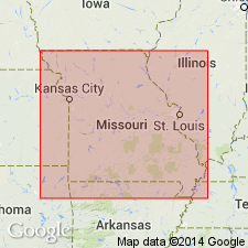
- Forest City basin
Summary:
Pg. 78-83, 100, 101, 102, 103, measured sections, pl. 5. Tebo formation of Cherokee group. Name Tebo was originally given to coal seam, type locality of which is on Tebo Creek, Henry County, east-central Missouri [C.F. Marbut, 1898, Missouri Geol. Survey, v. 12, p. 108-191]. Associated with coal is an underclay and overlying black roof slate which appear to make a unit. Name Tebo formation is applied to this unit. Unconformably overlies Loutre formation; unconformably underlies Ardmore formation. Thickness as much as 9 feet. [Age is Middle Pennsyvlanian (Des Moines).]
Source: US geologic names lexicon (USGS Bull. 1200, p. 3836-3837).
- Usage in publication:
-
- Tebo formation
- Modifications:
-
- Overview
- AAPG geologic province:
-
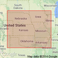
- Chautauqua platform
- Forest City basin
Summary:
Pg. 2748 (fig. 1). Stratigraphic column shows Tebo formation above Weir formation and below Scammon formation. Cabaniss group. Age is Middle Pennsylvanian (Des Moines).
Source: US geologic names lexicon (USGS Bull. 1200, p. 3836-3837).
- Usage in publication:
-
- Tebo coal cycle
- Modifications:
-
- Areal extent
- AAPG geologic province:
-
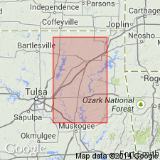
- Chautauqua platform
Summary:
Pg. 5. Listed as Tebo coal cycle in Senora formation, Cabaniss group in Oklahoma. [Age is Middle Pennsyvlanian (Des Moines).]
Source: US geologic names lexicon (USGS Bull. 1200, p. 3836-3837).

- Usage in publication:
-
- Tebo formation
- Modifications:
-
- Areal extent
- AAPG geologic province:
-
- Cherokee basin
Summary:
Pg. 22 (fig. 11), 23 (fig. 12). Tebo formation. Thickness about 17.5 feet in Vernon County, Missouri. Underlies Tiawah limestone in Scammon formation, Cabaniss group. [Age is Middle Pennsyvlanian (Des Moines).]
Source: US geologic names lexicon (USGS Bull. 1200, p. 3836-3837).
For more information, please contact Nancy Stamm, Geologic Names Committee Secretary.
Asterisk (*) indicates published by U.S. Geological Survey authors.
"No current usage" (†) implies that a name has been abandoned or has fallen into disuse. Former usage and, if known, replacement name given in parentheses ( ).
Slash (/) indicates name conflicts with nomenclatural guidelines (CSN, 1933; ACSN, 1961, 1970; NACSN, 1983, 2005, 2021). May be explained within brackets ([ ]).