

- Usage in publication:
-
- Tea Cup Granodiorite*
- Modifications:
-
- Named
- Geochronologic dating
- Dominant lithology:
-
- Granodiorite
- AAPG geologic province:
-
- Basin-and-Range province
Summary:
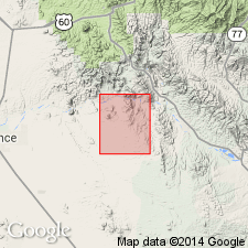
Is a pluton named for Tea Cup Ranch whose headquarters are in NW1/4 sec 7, T5S, R13E, Pinal Co, AZ, Basin-and-Range province. Typical exposures found along wash in SE1/4 sec 36, T4S, R12E; these exposures designated the type locality. Is typically medium- to coarse-grained granodiorite, hypidiomorphic with prominent medium-gray quartz crystals intergrown with gray plagioclase, K-feldspar, black biotite, and hornblende. Porphyritic in places with 6- to 12-mm feldspar and quartz phenocrysts in a fine-grained groundmass of K-feldspar, andesine, biotite, hornblende, and magnetite. Typical modal analysis included. Age is Paleocene based on K-Ar age of 62.9 +/-1.3 m.y. obtained on biotite; fission-track age of 61.4 +/-3.2 m.y. obtained on garnet. [Mapped in central and west part of map. Intrudes Pinal Schist (Precambrian X age) and Ruin Granite (Precambrian Y age). Intruded by Paleocene and younger Tertiary dikes of andesite, rhyodacite, quartz latite and rhyolite. --from US geologic names lexicon (USGS Bull. 1520) and GNU (1996).]
Source: GNU records (USGS DDS-6; Denver GNULEX).
- Usage in publication:
-
- Tea Cup Granodiorite*
- Modifications:
-
- Overview
- AAPG geologic province:
-
- Basin-and-Range province
Summary:
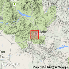
Crops out in Gila Co, AZ, Basin-and-Range province over an area of about 41 sq km, southwest of the Globe district. Total extent of pluton unknown. Equigranular phase is holocrystalline, phanerocrystalline, medium-grained, hypidiomorphic. Porphyritic phase has a phanerocrystalline, medium-grained, hypidiomorphic granular groundmass. Detailed description of composition. Geologic map. Has radiometric ages in m.y. of 61.4 +/-3.2 F-T on garnet, 68.6 +/-0.5 K-Ar on biotite, 61.8 +/-0.5 K-Ar on hornblende, 62.9 +/-1.3 and 62.5 +/-0.5 on biotite. Of Laramide age.
Source: GNU records (USGS DDS-6; Denver GNULEX).
For more information, please contact Nancy Stamm, Geologic Names Committee Secretary.
Asterisk (*) indicates published by U.S. Geological Survey authors.
"No current usage" (†) implies that a name has been abandoned or has fallen into disuse. Former usage and, if known, replacement name given in parentheses ( ).
Slash (/) indicates name conflicts with nomenclatural guidelines (CSN, 1933; ACSN, 1961, 1970; NACSN, 1983, 2005, 2021). May be explained within brackets ([ ]).