

- Usage in publication:
-
- Tea Creek dolomite
- Modifications:
-
- Original reference
- Dominant lithology:
-
- Dolomite
- AAPG geologic province:
-
- Appalachian basin
Summary:
Pg. F6, F14, F15 (geol. map). Tea Creek dolomite. At top of Bellefonte group. Consists almost wholly of medium-gray, in part red-flecked dololutite that weathers light, more or less yellowish gray, the weathered surface tending to be deeply gashed by incisions leached along the numerous joints that transect this type of rock. Thickness 200 feet. Includes Dale Summit sandstone member (new) near base. Suggested that Dale Summit sandstone may represent inauguration of Chazyan sedimentation. Underlies Milroy limestone (new). Overlies Coffee Run dolomite (new). Age is Early Ordovician.
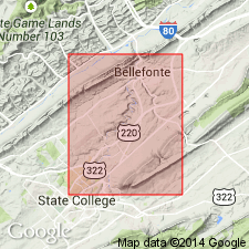
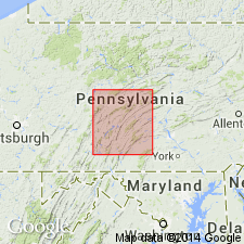
Type section: along Tea Creek in Kishacoquillas Valley, [near Reedsville, Brown Twp., Lewistown 15-min quadrangle], Mifflin Co., central PA. [Notable exposures] in area from Bellefonte to Pleasant Gap, Nittany Valley, central PA.
Source: US geologic names lexicon (USGS Bull. 1350, p. 750); GNU records (USGS DDS-6; Reston GNULEX).
- Usage in publication:
-
- Tea Creek Dolomite Member
- Modifications:
-
- Revised
- AAPG geologic province:
-
- Appalachian basin
Summary:
Revised the Tea Creek to the Tea Creek Dolomite Member of the Bellefonte Dolomite. Consists of aphanitic, light-brownish-gray to medium-gray dolomite. Overlies Coffee Run Member of Bellefonte and underlies Milroy Limestone. Includes measured section.
Source: GNU records (USGS DDS-6; Reston GNULEX).
- Usage in publication:
-
- Tea Creek Member
- Modifications:
-
- Revised
- Redescribed
- AAPG geologic province:
-
- Appalachian basin
Summary:
Revised the Tea Creek Member of the Bellefonte Dolomite by separating out lower unit, Dale Summit Member of Swartz (1955). Underlies Milroy Limestone.
Source: GNU records (USGS DDS-6; Reston GNULEX).
For more information, please contact Nancy Stamm, Geologic Names Committee Secretary.
Asterisk (*) indicates published by U.S. Geological Survey authors.
"No current usage" (†) implies that a name has been abandoned or has fallen into disuse. Former usage and, if known, replacement name given in parentheses ( ).
Slash (/) indicates name conflicts with nomenclatural guidelines (CSN, 1933; ACSN, 1961, 1970; NACSN, 1983, 2005, 2021). May be explained within brackets ([ ]).