The National Geologic Map Database is migrating to a new infrastructure. We apologize for any service disruptions during this process.
|
|---|


- Usage in publication:
-
- Tatum Limestone Member*
- Modifications:
-
- Named
- Dominant lithology:
-
- Limestone
- Marl
- AAPG geologic province:
-
- Mid-Gulf Coast basin
Summary:
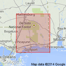
Pg. D44 (table), D45-D46. Tatum Limestone Member of Catahoula Sandstone. Catahoula Sandstone divided into an upper part, chiefly nonmarine sand and clay, and a lower part termed Tatum Limestone Member, a name introduced to replace "Limestone of the HETEROSTEGINA zone" or "HETEROSTEGINA limestone." Consists of sandy limestone, marl, glauconitic calcarenite, and calcirudite. Thickness 163 feet in well 1, from depth of 1,373 to 1,536 feet; 170 feet in well 2, from 1,470 to 1,640 feet. Thins to about 90 feet in southeastern part of area and thickens to 300 feet toward west. Recognized in subsurface of southern Mississippi, northern Florida, and Louisiana. Age is considered Oligocene(?) and Miocene(?); tentatively correlated with fossiliferous limestones and marls of the Paynes Hammock Sand (Miocene) and the upper bed of the Chickasawhay Limestone (Oligocene) as described by MacNeil (1944).
Type section (subsurface): U.S. Atomic Energy Commission hydrologic test well 1, in NE/4 SW/4 sec. 12, T. 2 N., R. 16 W., Tatum dome area, Lamar Co., MS; datum is 321 ft above sea level (Eargle, 1964).
Reference section (subsurface): U.S. Atomic Energy Commission hydrologic test well 2, in SW/4 SW/4 sec. 14, T. 2 N., R. 16 W.; datum is 302 ft above sea level.
Source: Publication; US geologic names lexicon (USGS Bull. 1350, p. 749).
For more information, please contact Nancy Stamm, Geologic Names Committee Secretary.
Asterisk (*) indicates published by U.S. Geological Survey authors.
"No current usage" (†) implies that a name has been abandoned or has fallen into disuse. Former usage and, if known, replacement name given in parentheses ( ).
Slash (/) indicates name conflicts with nomenclatural guidelines (CSN, 1933; ACSN, 1961, 1970; NACSN, 1983, 2005, 2021). May be explained within brackets ([ ]).