

- Usage in publication:
-
- Tampico shale member
- Modifications:
-
- Named
- Dominant lithology:
-
- Shale
- AAPG geologic province:
-
- Williston basin
Summary:
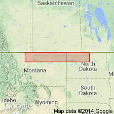
Named as the basal member of Piper formation. Type section is from interval 3,858 to 3,944 ft in Gulf Oil Corp. No. 1 Cornwell well, center SW1/4 NE1/4 sec 14, T30N, R38E, Valley Co, MT in Williston basin. Named for Tampico, west of the type well. Consists of 86 ft of gray-green calcareous shale which is slightly silty in middle of unit in type well. In some wells, unit contains large amount of interbedded red shale and occasionally thin beds of dense buff to brown limestone, gypsum, and white calcareous sandstone. Sandstones become well developed northward in SA, Canada. Red shales become more dominant southward in central and southern MT. Maintains fairly uniform thickness. Upper and lower boundaries more clearly defined in subsurface of northern MT than in outcrops in central and southern MT. Conformably underlies Firemoon limestone member (new). In subsurface, overlies Kline member of Nesson formation (new) with apparent conformity. Unconformably overlies Madison limestone west of Bowdoin dome and unconformably overlies beds ranging from Upper Mississippian through Triassic in central and south-central MT. Age is Middle Jurassic.
Source: GNU records (USGS DDS-6; Denver GNULEX).

- Usage in publication:
-
- Tampico Shale Member*
- Modifications:
-
- Overview
- AAPG geologic province:
-
- Williston basin
Summary:
Is basal member of Piper Formation. Is Middle Jurassic (Bajocian) in age. In central and eastern MT and western ND, in Williston basin. Summarized lithology, basis for dating, distribution, and correlation.
Source: GNU records (USGS DDS-6; Denver GNULEX).
For more information, please contact Nancy Stamm, Geologic Names Committee Secretary.
Asterisk (*) indicates published by U.S. Geological Survey authors.
"No current usage" (†) implies that a name has been abandoned or has fallen into disuse. Former usage and, if known, replacement name given in parentheses ( ).
Slash (/) indicates name conflicts with nomenclatural guidelines (CSN, 1933; ACSN, 1961, 1970; NACSN, 1983, 2005, 2021). May be explained within brackets ([ ]).