

- Usage in publication:
-
- Sylacauga marble member*
- Modifications:
-
- Named
- Dominant lithology:
-
- Marble
- AAPG geologic province:
-
- Appalachian basin
Summary:
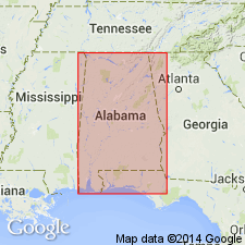
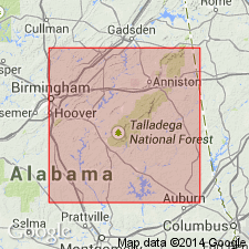
Sylacauga marble member of Talladega slate named in Talladega Co., AL. Unit is fine-grained white or cream-tinted translucent rock, more or less clouded with green, due to layers of green phyllite. No dolomite beds observed within the marble, but it undoubtedly is closely associated with large thicknesses of dolomite, which is believed to be of much later age than the marble. No fossils. Thickness at least 500 ft. Is in lower part of Talladega slate, probably 4,500+/-ft above base. Overlain and underlain by phyllite, and is believed by Prouty to be same as Sawyer limestone member. Prouty described the marble in Alabama Geological Survey Bulletin 18, 1916, but did not apply name to it. He expressed opinion the marble is of various ages, from Late Cambrian (Conasauga) to Ordovician (Chickamauga). Present writer believes it is all of same age and that it all lies in Talladega slate.
Source: GNU records (USGS DDS-6; Reston GNULEX).
- Usage in publication:
-
- Sylacauga Marble Group
- Modifications:
-
- Revised
- AAPG geologic province:
-
- Appalachian basin
Summary:
Sylacauga marble member of Butts (1926) is here expanded to include carbonate sequence, especially Jumbo Dolomite, and is raised in rank to Sylacauga Marble Group. Unit is 1700 m thick. Underlies Lay Dam Formation of Talladega Group and overlies Kahatchee Mountain Group. Age is early Paleozoic.
Source: GNU records (USGS DDS-6; Reston GNULEX).
- Usage in publication:
-
- Sylacauga Marble Group
- Modifications:
-
- Revised
- AAPG geologic province:
-
- Appalachian basin
Summary:
In Talladega and Coosa Cos, AL, Sylacauga Marble Group divided into five mappable units (ascending): Jumbo Dolomite, Fayetteville Phyllite (named), Shelvin Rock Church Formation (named), Gooch Branch Chert (named), and Gantts Quarry Formation (named). Thickness of Group ranges from 2 to 3.5 km. Overlies Kahatchee Mountain Group. Unconformably underlies Lay Dam Formation of Talladega Group. Age given as early Paleozoic or older.
Source: GNU records (USGS DDS-6; Reston GNULEX).
- Usage in publication:
-
- Sylacauga Marble Group
- Modifications:
-
- Overview
- Age modified
- AAPG geologic province:
-
- Appalachian basin
Summary:
Sylacauga Marble Group is sequence of calcite and dolomite marbles, pelitic units, and cherty dolomites. Thins from 3.5 km on the northeast to a feather edge on the southwest. Recent fossil discoveries confirm correlation with Cambrian-Ordovician carbonate sequence of the foreland thrust belt to the northwest. Early Cambrian archaeocyathids have been recovered from the Jumbo Dolomite (lowermost unit) and Early Ordovician conodonts from the Gantts Quarry Formation (uppermost unit). Unconformity at the top of the Sylacauga is bracketed as Early Ordovician to Early Devonian in age.
Source: GNU records (USGS DDS-6; Reston GNULEX).
For more information, please contact Nancy Stamm, Geologic Names Committee Secretary.
Asterisk (*) indicates published by U.S. Geological Survey authors.
"No current usage" (†) implies that a name has been abandoned or has fallen into disuse. Former usage and, if known, replacement name given in parentheses ( ).
Slash (/) indicates name conflicts with nomenclatural guidelines (CSN, 1933; ACSN, 1961, 1970; NACSN, 1983, 2005, 2021). May be explained within brackets ([ ]).