The National Geologic Map Database is migrating to a new infrastructure. We apologize for any service disruptions during this process.
|
|---|


- Usage in publication:
-
- Sycamore limestone*
- Modifications:
-
- Original reference
- Dominant lithology:
-
- Limestone
- AAPG geologic province:
-
- South Oklahoma folded belt
Summary:
Sycamore limestone. Dense, even-textured bluish limestone, which weathers to yellowish hues and is hard and tough. Thickness 0 to 160 feet. Increases in thickness to west. Overlies Woodford chert and underlies Caney shale. [Age is Early Mississippian (Kinderhook).]
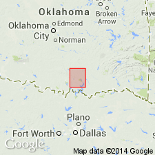
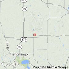
[Named from Sycamore Creek, which crosses its outcrop in T. 3 S., R. 4 E., Johnston Co., Arbuckle Mountains, central southern OK.]
Source: US geologic names lexicon (USGS Bull. 896, p. 2102).

- Usage in publication:
-
- Sycamore limestone*
- Modifications:
-
- Age modified
- AAPG geologic province:
-
- South Oklahoma folded belt
Summary:
According to E.O. Ulrich, C. Schuchert, and R.C. Moore the Sycamore fauna is of Kinderhook age.
Source: US geologic names lexicon (USGS Bull. 896, p. 2102).
- Usage in publication:
-
- Sycamore sandstone
- Modifications:
-
- Overview
- AAPG geologic province:
-
- South Oklahoma folded belt
Summary:
Pg. 22, 23. Sycamore sandstone exposed below Caney type section is unlike Sycamore of its type area and may be facies grading into Ahloso member of Caney.
Source: US geologic names lexicon (USGS Bull. 1200, p. 3796).
- Usage in publication:
-
- Sycamore formation
- Modifications:
-
- Revised
- AAPG geologic province:
-
- South Oklahoma folded belt
Summary:
Pg. 156-164. Sycamore formation. In Ardmore basin, formation occupies stratigraphic interval between Caney (Meramecian) and Woodford (upper part Kinderhookian) formations. Divisible into two members, herein named Cornell Ranch (lower) and Worthey (upper). Consists of slate-blue tough silty to finely sandy limestone with calcareous shales ranging from very thin partings to lentils up to 30 feet thick. Lower part contains cherty limestones and calcareous shales, with a green shale at base. Near base is bed of limestone, typically glauconitic at base, becoming cherty in upper part. Total thickness up to 350 feet. Age is Mississippian.
Source: US geologic names lexicon (USGS Bull. 1200, p. 3796).
For more information, please contact Nancy Stamm, Geologic Names Committee Secretary.
Asterisk (*) indicates published by U.S. Geological Survey authors.
"No current usage" (†) implies that a name has been abandoned or has fallen into disuse. Former usage and, if known, replacement name given in parentheses ( ).
Slash (/) indicates name conflicts with nomenclatural guidelines (CSN, 1933; ACSN, 1961, 1970; NACSN, 1983, 2005, 2021). May be explained within brackets ([ ]).