The National Geologic Map Database is migrating to a new infrastructure. We apologize for any service disruptions during this process.
|
|---|


- Usage in publication:
-
- Sycamore Canyon formation
- Modifications:
-
- Original reference
- AAPG geologic province:
-
- Los Angeles basin
Summary:
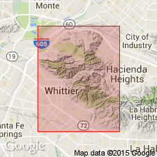
Name Sycamore Canyon formation applied to a 3,800 foot interval of alternating conglomerates, sands, silts, and shales in Whittier Hills, [Los Angeles County], southern California. Underlies Repetto formation; unconformably overlies upper Puente member of Puente formation. [Age is late Miocene.]
Source: US geologic names lexicon (USGS Bull. 1200, p. 3797).
- Usage in publication:
-
- Sycamore Canyon member*
- Modifications:
-
- Revised
- AAPG geologic province:
-
- Los Angeles basin
Summary:
Sycamore Canyon member of Puente formation. Described in Whittier area [Los Angeles County, southern California]. Rank reduced to member of Puente formation. Lower beds of conglomerate lens out within map area and in places interfinger with beds of underlying siltstone. [Age is late Miocene.]
Source: US geologic names lexicon (USGS Bull. 1200, p. 3797).
- Usage in publication:
-
- Sycamore Canyon member*
- Modifications:
-
- Areal extent
- AAPG geologic province:
-
- Los Angeles basin
Summary:
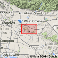
Pg. 6-7. Sycamore Canyon member of Puente formation. In Whittier-La Habra area [Los Angeles County, southern California], member subdvided into Central Fee sandstone below and Hoover conglomerate above. Age is late Miocene.
Source: US geologic names lexicon (USGS Bull. 1200, p. 3797).
- Usage in publication:
-
- Sycamore Canyon member*
- Modifications:
-
- Mapped 1:24k
- Dominant lithology:
-
- Sandstone
- Siltstone
- AAPG geologic province:
-
- Los Angeles basin
Summary:
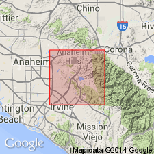
Sycamore Canyon member of Puente formation. Use of name extended to include the massive to well-bedded feldspathic sandstones, gray to brown siltstone, and local conglomerates that crop out [in Orange County, southern California], in southeastern end of Puente Hills, between Chino and the Santa Ana River, and on Burruel Ridge south of Santa Ana River. On Burruel Ridge, the Sycamore Canyon is unconformably overlain by Repetto(?) and gradationally overlies Yorba member (new) of Puente. Age is late Miocene.
Source: Publication; US geologic names lexicon (USGS Bull. 1200, p. 3797).
For more information, please contact Nancy Stamm, Geologic Names Committee Secretary.
Asterisk (*) indicates published by U.S. Geological Survey authors.
"No current usage" (†) implies that a name has been abandoned or has fallen into disuse. Former usage and, if known, replacement name given in parentheses ( ).
Slash (/) indicates name conflicts with nomenclatural guidelines (CSN, 1933; ACSN, 1961, 1970; NACSN, 1983, 2005, 2021). May be explained within brackets ([ ]).