

- Usage in publication:
-
- Sunday quartzite*
- Modifications:
-
- Original reference
- AAPG geologic province:
-
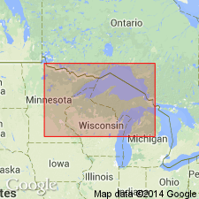
- Lake Superior region
Summary:
Pg. 225, 227, chart opp. p. 598, 605. Sunday quartzite. Mainly quartzite, at least 150 feet thick, with basal conglomerate from a few inches to 10 feet thick. Grades into overlying Bad River limestone. Rests unconformably on Archean. May be same as Mesnard quartzite of Marquette district. Age is Precambrian (early Huronian).
Named from two exposures east of Sunday Lake, one a short distance east of Little Presque Isle River and the other near Newport mine, Penokee-Gogebic district, Northern Peninsula, northwestern MI.
Source: US geologic names lexicon (USGS Bull. 896, p. 2087).
- Usage in publication:
-
- Sunday Quartzite*
- Modifications:
-
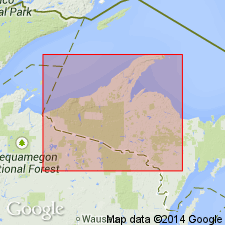
- Areal extent
- AAPG geologic province:
-
- Lake Superior region
Summary:
Pg. 2845 (fig. 2, stratigraphic chart compiled from Leith and others, 1935; James, 1958; Gair and Thaden, 1968). Sunday Quartzite of Chocolay Group of Marquette Range Supergroup (new; replaces †Animikie series of James, 1958, south of Lake Superior, in Michigan and Wisconsin). Present in Gogebic Range, northwestern Michigan. Underlies Bad River Dolomite of Chocolay Group; unconformably overlies lower Precambrian gneiss. Age is middle Precambrian.
Source: Publication.
For more information, please contact Nancy Stamm, Geologic Names Committee Secretary.
Asterisk (*) indicates published by U.S. Geological Survey authors.
"No current usage" (†) implies that a name has been abandoned or has fallen into disuse. Former usage and, if known, replacement name given in parentheses ( ).
Slash (/) indicates name conflicts with nomenclatural guidelines (CSN, 1933; ACSN, 1961, 1970; NACSN, 1983, 2005, 2021). May be explained within brackets ([ ]).