The National Geologic Map Database is migrating to a new infrastructure. We apologize for any service disruptions during this process.
|
|---|


- Usage in publication:
-
- Stover member
- Modifications:
-
- Named
- Dominant lithology:
-
- Limestone
- AAPG geologic province:
-
- Appalachian basin
Summary:
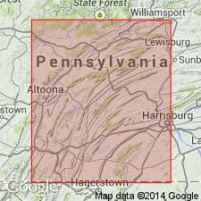
Named the Stover member of the Benner limestone for Stover station, near Nealmont, Blair Co., south-central PA. Unit is upper member of Benner. Consists of dark, principally dense, heavy ledged limestone. Ledges have thin stylotitic partings and fucoidal mottling. One thick metabentonite bed exposed in several sections. Thickness is 91 feet at type section and decreases southeastward. Overlies Snyder member of Benner and underlies Valley View member of Curtin limestone in northern Centre, Clinton, and Lycoming Cos., and southeastward, disconformably underlies Nealmont limestone. The Stover is of Middle Ordovician age.
Source: GNU records (USGS DDS-6; Reston GNULEX).
- Usage in publication:
-
- Stover limestone
- Modifications:
-
- Areal extent
- Revised
- AAPG geologic province:
-
- Appalachian basin
Summary:
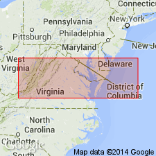
Raised the Stover Limestone to formation rank and geographically extended it to western VA and eastern WV. Listed in stratigraphic column for Highland Co., VA and Monroe Co., WV.
Source: GNU records (USGS DDS-6; Reston GNULEX).
- Usage in publication:
-
- Stover limestone
- Modifications:
-
- Areal extent
- AAPG geologic province:
-
- Appalachian basin
Summary:
Geographically restricted the Stover limestone from western VA. McGraw limestone proposed for rocks in VA previously called Stover.
Source: GNU records (USGS DDS-6; Reston GNULEX).
For more information, please contact Nancy Stamm, Geologic Names Committee Secretary.
Asterisk (*) indicates published by U.S. Geological Survey authors.
"No current usage" (†) implies that a name has been abandoned or has fallen into disuse. Former usage and, if known, replacement name given in parentheses ( ).
Slash (/) indicates name conflicts with nomenclatural guidelines (CSN, 1933; ACSN, 1961, 1970; NACSN, 1983, 2005, 2021). May be explained within brackets ([ ]).