

- Usage in publication:
-
- Stearns Granitic Complex
- Modifications:
-
- Redescribed
- Dominant lithology:
-
- Granite
- AAPG geologic province:
-
- Lake Superior region
Summary:
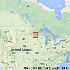
Redescribed because rank name replaces Stearns magma series of Woyski (1949) in east-central MN in the Lake Superior region. Includes St. Cloud (redescribed) and Rockville Granites. Unit is part of northeast-trending pluton about 80 km long and 32 km wide. Outcrops over wide area in western Mille Lacs Co, northwestern, central and western Benton Co, eastern and northeastern Stearns Co, southeastern Morrison Co, and northwestern Sherburne Co. Forms youngest granitic pluton in region because it contains inclusions derived from older units described in report. Geologic map. Are youngest middle Precambrian rocks shown on map correlation.
Source: GNU records (USGS DDS-6; Denver GNULEX).
For more information, please contact Nancy Stamm, Geologic Names Committee Secretary.
Asterisk (*) indicates published by U.S. Geological Survey authors.
"No current usage" (†) implies that a name has been abandoned or has fallen into disuse. Former usage and, if known, replacement name given in parentheses ( ).
Slash (/) indicates name conflicts with nomenclatural guidelines (CSN, 1933; ACSN, 1961, 1970; NACSN, 1983, 2005, 2021). May be explained within brackets ([ ]).