

- Usage in publication:
-
- St. Wendel Metagabbro
- Modifications:
-
- Named
- Dominant lithology:
-
- Metagabbro
- Gneiss
- AAPG geologic province:
-
- Lake Superior region
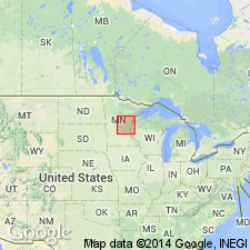
Summary:
Named for dark-gray and black gneissic rocks belonging to Sauk Rapids Metamorphic Complex (new). Outcrops located in SW1/4 sec 12 and NE1/4 sec 13, T125N, R29W, northeastern Stearns Co, east-central MN, Lake Superior region. Type locality designated as abandoned quarry in SE1/4 SE1/4 sec 12. Unit forms series of lenticular bodies ranging in size from about 300 m to 2 km long; bodies are elongated, easterly, and parallel to foliation of enclosing Sartell Gneiss. Consists mostly of dark-greenish-gray to greenish-black plagioclase-clinopyroxene gneiss characterized by [plagioclase] grains with diameter of as much as 8 mm. Lesser amounts of interstitial quartz and replacive chlorite. Geologic map. Is early Precambrian in age.
Source: GNU records (USGS DDS-6; Denver GNULEX).
For more information, please contact Nancy Stamm, Geologic Names Committee Secretary.
Asterisk (*) indicates published by U.S. Geological Survey authors.
"No current usage" (†) implies that a name has been abandoned or has fallen into disuse. Former usage and, if known, replacement name given in parentheses ( ).
Slash (/) indicates name conflicts with nomenclatural guidelines (CSN, 1933; ACSN, 1961, 1970; NACSN, 1983, 2005, 2021). May be explained within brackets ([ ]).