The National Geologic Map Database is migrating to a new infrastructure. We apologize for any service disruptions during this process.
|
|---|


- Usage in publication:
-
- St. Daniel Formation
- Modifications:
-
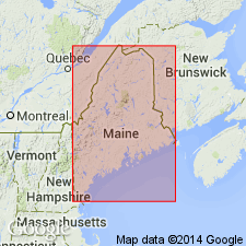
- Areal extent
- AAPG geologic province:
-
- New England province
Summary:
Following the usage of the State map (Osberg and others, 1985), Saint [St.] Daniel Formation is extended from CAN to replace the Estcourt Road Formation of Roy (1980). The outcrop width of the unit in ME, however, is much wider than mapped by Canadian geologists in the Eastern Townships of Quebec. In ME consists largely of disrupted Caldwell and Rosaire Groups and does not strictly conform to the definition of the Saint Daniel melange in its type area. Current detailed mapping by S.G. Pollock may result in redefinition or revision. As designated in report area, composed of two types metasedimentary sequences. Sequence I consists gray and black phyllite interlayered with beds of calcareous, quartzose, fine-grained sandstone and siltstone. Locally contains blocks of limestone and quartzite. Sequence II consists red and lesser green slate interbedded with red, green, and white thick-bedded quartzite and feldspathic quartzite. Both sequences show bedding transposition. Unit is everywhere separated from the Depot Mountain Formation by the Dead Brook fault. Late Cambrian to Middle Ordovician age inferred from regional considerations. Caldwell and Rosaire Groups are Early to Late(?) Cambrian, hence the tectonic disruption of these units that formed the St. Daniel falls between the Late Cambrian and Middle Ordovician.
Source: GNU records (USGS DDS-6; Reston GNULEX).
For more information, please contact Nancy Stamm, Geologic Names Committee Secretary.
Asterisk (*) indicates published by U.S. Geological Survey authors.
"No current usage" (†) implies that a name has been abandoned or has fallen into disuse. Former usage and, if known, replacement name given in parentheses ( ).
Slash (/) indicates name conflicts with nomenclatural guidelines (CSN, 1933; ACSN, 1961, 1970; NACSN, 1983, 2005, 2021). May be explained within brackets ([ ]).