The National Geologic Map Database is migrating to a new infrastructure. We apologize for any service disruptions during this process.
|
|---|


- Usage in publication:
-
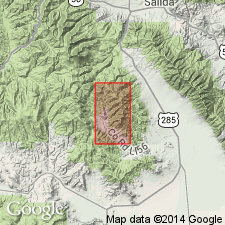
- Squirrel Gulch latite*
- Modifications:
-
- Named
- Dominant lithology:
-
- Latite
- AAPG geologic province:
-
- San Luis basin
Summary:
Named for development in upper part of Squirrel Gulch, Saguache Co, CO in the San Luis basin. Is characterized by massive flows of hornblende-biotite latite. Confined to a narrow zone in west part of area. Ranges from 300-500 ft thick. Overlies Bonanza latite; intertongues and grades into Porphyry Peak rhyolite; is contemporaneous with Hayden Peak latite. Mapped (geologic map) in south-central and west part of district. Is of Tertiary age.
Source: GNU records (USGS DDS-6; Denver GNULEX).
For more information, please contact Nancy Stamm, Geologic Names Committee Secretary.
Asterisk (*) indicates published by U.S. Geological Survey authors.
"No current usage" (†) implies that a name has been abandoned or has fallen into disuse. Former usage and, if known, replacement name given in parentheses ( ).
Slash (/) indicates name conflicts with nomenclatural guidelines (CSN, 1933; ACSN, 1961, 1970; NACSN, 1983, 2005, 2021). May be explained within brackets ([ ]).