

- Usage in publication:
-
- Spud Mountain volcanics*
- Modifications:
-
- Named
- Dominant lithology:
-
- Breccia
- Andesite
- Rhyolite
- Basalt
- AAPG geologic province:
-
- Southwestern Basin-and-Range region
Summary:
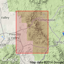
Are named as a formation of the Alder group of Yavapai series. A representative section [type section?] is exposed from Spud Mountain to the Iron King mine [secs 16, 17, 20, and 21, T13N, R1E], Yavapai Co, AZ, Southwestern Basin-and-Range region. Contains 1) andesitic breccia, 2) andesitic tuff, 3) rhyolitic tuff, and 4) andesitic and basaltic flows. 1) Fine-grained tuffaceous sedimentary rocks included with andesitic breccia probably more than 500 ft thick but breccia predominates. Fragments, chiefly andesite, some rhyolite, in breccia range from less than 1 to about 18 in long, are commonly subrounded, vary in size in different beds. 2) Conglomerate beds occur sporadically in the andesitic tuff of varying shades of green, which is sedimentary composed of andesitic detritus. Fragments range from clay to cobble size. 3) Two varieties of rhyolitic tuff exist, one coarse grained, the other feldspathic. 4) The flows are massive and uniform. Are thousands of feet thick. Overlie Indian Hills volcanics and apparently overlain by Iron King volcanics (new) of Alder group. Are older Precambrian. Geologic map.
Source: GNU records (USGS DDS-6; Denver GNULEX).
- Usage in publication:
-
- Spud Mountain Volcanics*
- Modifications:
-
- Revised
- Geochronologic dating
- AAPG geologic province:
-
- Southwestern Basin-and-Range region
Summary:
Is removed from abandoned Alder Group and made middle formation of newly named Big Bug Group in Mount Vernon, Mayer, Mingus Mountain, and Prescott quads, Yavapai Co, AZ, Southwestern Basin-and-Range region. Zircons from rhyolite flow in upper part of formation in Prescott-Jerome area, AZ, yield an isotopic age of 1,775 +/-10 ma.
Source: GNU records (USGS DDS-6; Denver GNULEX).
For more information, please contact Nancy Stamm, Geologic Names Committee Secretary.
Asterisk (*) indicates published by U.S. Geological Survey authors.
"No current usage" (†) implies that a name has been abandoned or has fallen into disuse. Former usage and, if known, replacement name given in parentheses ( ).
Slash (/) indicates name conflicts with nomenclatural guidelines (CSN, 1933; ACSN, 1961, 1970; NACSN, 1983, 2005, 2021). May be explained within brackets ([ ]).