

- Usage in publication:
-
- Split Creek shale and sandstone member
- Modifications:
-
- Original reference
- Dominant lithology:
-
- Sandstone
- Shale
- AAPG geologic province:
-
- Alaska Southern region
Summary:
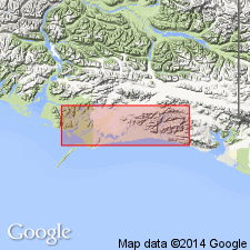
Pg. 771-775. Split Creek shale and sandstone member of Katalla formation. Basal member of Katalla formation. Consists of 800 feet of sandstone grading down into hard dark-colored, rather platy shales, 700 feet of which are exposed. Exposed only in northern part of area, in drainage to Bering Lake, in very narrow belt along Bering River, and in northern part of ridge between Redwood Creek and Katalla River. [Origin of name not stated.] Assigned to upper Oligocene, on basis of correlation with similar fossiliferous rocks in Yakataga district, which are assigned to upper Oligocene by B.L. Clark. Conformably overlain by Burls Creek shale member of Katalla formation.
[GNC remark (ca. 1936, US geologic names lexicon, USGS Bull. 896, p. 2041): The USGS classifies typical Katalla formation as Miocene(?).]
Source: US geologic names lexicon (USGS Bull. 896, p. 2041).
- Usage in publication:
-
- Split Creek Sandstone Member*
- Modifications:
-
- Principal reference
- Revised
- AAPG geologic province:
-
- Alaska Southern region
Summary:
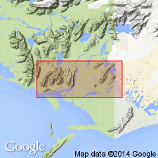
Split Creek Sandstone Member of Miller and others (1945) is retained as basal member of Katalla Formation. Underlying shale unit is reassigned to underlying Tokun Formation as its uppermost member because lithology more closely resembles gross lithology of Tokun. Split Creek Sandstone Member is well exposed in valley of Split Creek; type section designated at head of Split Creek [northeast of Katalla, Katalla district, Controller Bay region, southeastern Alaska] where thickness is 1,000 feet. Based on mollusks in unit, F.S. MacNeil concluded that age is "approximately middle and possibly lower Lincoln (middle Oligocene)."
Source: GNU records (USGS DDS-6; Menlo GNULEX).
- Usage in publication:
-
- Split Creek Sandstone Member*
- Modifications:
-
- Revised
- AAPG geologic province:
-
- Alaska Southern region
Summary:
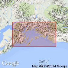
Reassigned to Poul Creek Formation due to abandonment of Katalla Formation in favor of Poul Creek Formation. [Age remains middle Oligocene.]
Source: GNU records (USGS DDS-6; Menlo GNULEX).
For more information, please contact Nancy Stamm, Geologic Names Committee Secretary.
Asterisk (*) indicates published by U.S. Geological Survey authors.
"No current usage" (†) implies that a name has been abandoned or has fallen into disuse. Former usage and, if known, replacement name given in parentheses ( ).
Slash (/) indicates name conflicts with nomenclatural guidelines (CSN, 1933; ACSN, 1961, 1970; NACSN, 1983, 2005, 2021). May be explained within brackets ([ ]).