

- Usage in publication:
-
- Spavinaw Granite
- Modifications:
-
- Geochronologic dating
- AAPG geologic province:
-
- Midcontinent region
Summary:
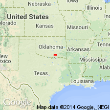
U-Pb measurements on zircons yield an age of 1370 +/-20 m.y. Unit has limited outcrops along Spavinaw Creek in Mayes Co, northeast OK, Midcontinent region.
Source: GNU records (USGS DDS-6; Denver GNULEX).
- Usage in publication:
-
- Spavinaw granite-rhyolite terrane*
- Modifications:
-
- Areal extent
- Geochronologic dating
- Overview
- AAPG geologic province:
-
- Midcontinent region
Summary:
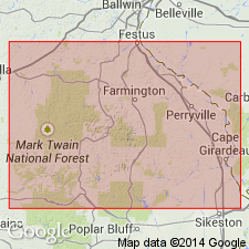
Exposed in few small outcrops near Spavinaw, Mayes Co, OK, Midcontinent region, however, data from over 300 drillholes indicate that terrane underlies most of northeast OK, eastern KS, southwest MO, and northern AR. Spavinaw consists of anorogenic epizonal granite and rhyolite that have not been regionally metamorphosed. Terrane includes Washington Volcanic Group, Spavinaw Granite Group, Osage Microgranite and Central Oklahoma Granite Group. U/Pb ages taken on zircons by other workers date Spavinaw at 1.40-1.35 Ga.
Source: GNU records (USGS DDS-6; Denver GNULEX).
For more information, please contact Nancy Stamm, Geologic Names Committee Secretary.
Asterisk (*) indicates published by U.S. Geological Survey authors.
"No current usage" (†) implies that a name has been abandoned or has fallen into disuse. Former usage and, if known, replacement name given in parentheses ( ).
Slash (/) indicates name conflicts with nomenclatural guidelines (CSN, 1933; ACSN, 1961, 1970; NACSN, 1983, 2005, 2021). May be explained within brackets ([ ]).