The National Geologic Map Database is migrating to a new infrastructure. We apologize for any service disruptions during this process.
|
|---|


- Usage in publication:
-
- Spadra felsophyre
- Modifications:
-
- Named
- Dominant lithology:
-
- Lava
- Breccia
- Limestone
- AAPG geologic province:
-
- Los Angeles basin
- Transverse Ranges province
Summary:
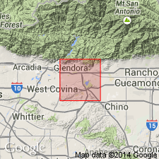
Named as member of Glendora volcanics. Occurs in isolated area east of Spadra and 2 mi southwest of Pomona, Los Angeles Co, CA. Exposed over area of .75 sq mi. Consists of fine-grained laminated flows and flow breccias. Locally includes lenses of limestone 40 ft thick. Thickness of unit is about 350 ft. Overlies plutonic basement rocks. Underlies Puente formation or alluvium. Age of Glendora volcanics shown as middle Miocene or older.
Source: GNU records (USGS DDS-6; Menlo GNULEX).
For more information, please contact Nancy Stamm, Geologic Names Committee Secretary.
Asterisk (*) indicates published by U.S. Geological Survey authors.
"No current usage" (†) implies that a name has been abandoned or has fallen into disuse. Former usage and, if known, replacement name given in parentheses ( ).
Slash (/) indicates name conflicts with nomenclatural guidelines (CSN, 1933; ACSN, 1961, 1970; NACSN, 1983, 2005, 2021). May be explained within brackets ([ ]).