The National Geologic Map Database is migrating to a new infrastructure. We apologize for any service disruptions during this process.
|
|---|


- Usage in publication:
-
- South Mound Shale Member
- Modifications:
-
- Named
- Dominant lithology:
-
- Shale
- AAPG geologic province:
-
- Cherokee basin
Summary:
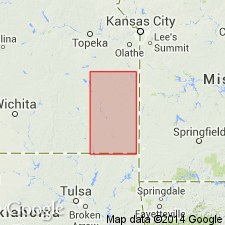
Named as upper member of Seminole Formation of Pleasanton Group for town of South Mound, southeastern Neosho Co., KS in the Cherokee basin. Type section about 20 mi southwest, 0.5 mi south of Mound Valley, in SE SW sec 2, T33S, R18E, Labette Co., KS. Outcrop area in KS equals that of Seminole Formation, from OK-KS border north to central Neosho Co. Not recognized in Linn Co. and north. Type section comprises gray shale and underclay containing silicified wood fragments, 1.0 ft; coal, 0.3 ft; upper gray shale containing crinoid fragments, brachiopods DERBYIA, COMPOSITA, gastropods, 6.5 ft; total 7.8 ft. Between Hepler Sandstone Member of the Seminole below and Checkerboard Limestone above. In sec 19, T34S, R17E Hepler is absent; there, base of Seminole and base of Pleasanton Group defined as change from maroon upward into gray in shale section. Thickness ranges from a few inches to 8 ft. Is of early Missourian, Late Pennsylvanian age.
Source: GNU records (USGS DDS-6; Denver GNULEX).
For more information, please contact Nancy Stamm, Geologic Names Committee Secretary.
Asterisk (*) indicates published by U.S. Geological Survey authors.
"No current usage" (†) implies that a name has been abandoned or has fallen into disuse. Former usage and, if known, replacement name given in parentheses ( ).
Slash (/) indicates name conflicts with nomenclatural guidelines (CSN, 1933; ACSN, 1961, 1970; NACSN, 1983, 2005, 2021). May be explained within brackets ([ ]).