The National Geologic Map Database is migrating to a new infrastructure. We apologize for any service disruptions during this process.
|
|---|


- Usage in publication:
-
- South Fork Mountain schist
- Modifications:
-
- Areal extent
- Dominant lithology:
-
- Schist
- AAPG geologic province:
-
- California Coast Ranges province
Summary:
Pg. 28-30. South Fork Mountain schist. Name applied in California to schists that have been referred to as southwestern belt of schists and South Fork Mountain belt of schists (Diller, 1903a, Amer. Jour. Sci., 4th ser., v. 15); Weitchpec schist (Hershey, 1904, Amer. Geol., v. 33, and 1906, Amer. Jour. Sci., 4th ser., v. 21); and Kerr Ranch schist (Manning and Ogle, 1950, California Div. Mines Bull., no. 148). In southwestern Oregon, seemingly related rocks were named Colebrooke schist (Diller, 1903b, USGS Geol. Atlas, Folio 89). Age and formational affiliation of South Fork Mountain schist is not entirely clear, but generally the schist has been considered pre-Devonian, or perhaps Precambrian, and genetically unrelated to adjacent formations. South Fork Mountain schist has most commonly been correlated with Abrams formation of central metamorphic belt of Klamath Mountains arc. However, more than one adjacent formation is at least in part a lithologically suitable prototype for the schist, and one of these, the Galice, appears to grade into the schist near Weitchpec. The schist may represent narrow zone of dynamic metamorphism, and although the metamorphism may have transgressed formational boundaries, most if not all of the schist is likely a metamorphic equivalent of the slaty and phyllitic rocks herein correlated with Galice formation of middle Late Jurassic age. On west slope of South Fork Mountains and northward to near Weitchpec, the schist is in contact with nonmetamorphic rocks of Franciscan formation. Rocks of late Late Jurassic and Cretaceous age are not known to be in depositional contact with South Fork Mountain schist in California. In southwestern Oregon, the younger Mesozoic rocks are in depositional contact with Colebrooke schist, and the Colebrooke is considered correlative with South Fork Mountain schist.
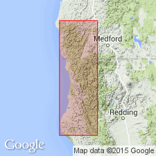
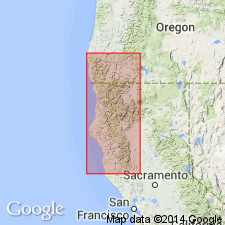
Underlies a continuous even-crested ridge that marks the southern and most of the western boundary of Klamath Mountains provinces. Southwestern boundary of province is South Fork Mountains which trend N. 30° W. for about 50 miles along west side of South Fork by Trinity River.
Source: US geologic names lexicon (USGS Bull. 1200, p. 3668-3669).
- Usage in publication:
-
- South Fork Mountain Schist*
- Modifications:
-
- Principal reference
- Dominant lithology:
-
- Schist
- AAPG geologic province:
-
- California Coast Ranges province
Summary:
Pg. C2 (fig. 1, geol. sketch map), C5-C6. South Fork Mountain Schist. The schist of South Fork Mountain (Diller, 1903a, Amer. Jour. Sci., 4th ser., v. 15) here named South Fork Mountain Schist. Recognized from Pickett Peak area southeastward to Black Butte area [in Hull Mountain 15-min quadrangle, Lake County, Mendocino National Forest, northwestern California]. Name restricted to rocks of textural zone 3 of blueschist facies, as shown on geologic sketch map (fig. 1) of northwestern California and southwestern Oregon. North of Pickett Peak quadrangle, rocks of textural zones 2 and 3 have not been divided and have been called Weitchpec Schist near Weitchpec (Hershey, 1904, 1906), Kerr Ranch Schist on Redwood Mountain (Manning and Ogle, 1950), and Colebrooke Schist in southwestern Oregon (Diller, 1903b, USGS Geol. Atlas, Folio 89). Metabasaltic rocks in South Fork Mountain Schist are here named Chinquapin Metabasalt Member. Metamorphic age is believed to be Late(?) Cretaceous based on stratigraphic relations with textural zones 1 and 2 which have radiometric (Rb-Sr) age of 105 +/-16 Ma (Z.E. Peterman and others, unpub. data).
Type locality: Pickett Peak on South Fork Mountain, in sec. 26, T. 29 N., R. 7 E., [approx. Lat. 40 deg. 20 min. 45 sec. N., Long. 123 deg. 21 min. 50 sec. W., near bdry. btw. Trinity and Six Rivers National Forests], Pickett Peak 15-min quadrangle, Trinity Co., northwestern CA.
[Additional locality information from USGS historical topographic map collection TopoView, accessed April 15, 2023.]
Source: Publication; GNU records (USGS DDS-6; Menlo GNULEX).
- Usage in publication:
-
- South Fork Mountain Schist*
- Modifications:
-
- Revised
- AAPG geologic province:
-
- California Coast Ranges province
Summary:
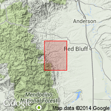
South Fork Mountain Schist mapped as part of Franciscan assemblage west of Coast Range thrust, in Colyear Springs 15-min quadrangle, Tehama County, California. Described as fine-grained foliated metasedimentary rock (textural zone III of blueschist facies) containing abundant quartz veins. Includes Chinquapin Metabasalt Member.
Source: Modified from GNU records (USGS DDS-6; Menlo GNULEX).
- Usage in publication:
-
- South Fork Mountain Schist*
- Modifications:
-
- Age modified
- Geochronologic dating
- AAPG geologic province:
-
- California Coast Ranges province
Summary:
South Fork Mountain Schist. Samples collected from Yolla Bolly area and Pickett Peak 15-min quadrangle, Trinity Co., CA. Radiometric age dates suggest South Fork Mountain Schist and its Chinquapin Metabasalt Member formed during Early Cretaceous metamorphic event. Whole-rock K-Ar ages range from 130 to 112 Ma; best estimate 120 to 115 Ma.
Source: Modified from GNU records (USGS DDS-6; Menlo GNULEX).
For more information, please contact Nancy Stamm, Geologic Names Committee Secretary.
Asterisk (*) indicates published by U.S. Geological Survey authors.
"No current usage" (†) implies that a name has been abandoned or has fallen into disuse. Former usage and, if known, replacement name given in parentheses ( ).
Slash (/) indicates name conflicts with nomenclatural guidelines (CSN, 1933; ACSN, 1961, 1970; NACSN, 1983, 2005, 2021). May be explained within brackets ([ ]).