

- Usage in publication:
-
- Souris River formation*
- Modifications:
-
- Overview
- Reference
- Dominant lithology:
-
- Siltstone
- Limestone
- Dolomite
- AAPG geologic province:
-
- Williston basin
- Central Montana uplift
- Sweetgrass arch
Summary:
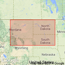
Although named and type section designated at a meeting, no definition has ever been published. Present authors designate the Mobil Producing Co. No. 1 Birdbear well in C SE NW1/4 sec 22, T149N, R91W, Dunn Co, ND in the Williston basin, as the standard subsurface [reference] section in the interval between 10,743 and 11,052 ft. Consists of gray interbedded siltstone, limestone, dolomite, shale, and anhydrite, and a very minor amount of dolomite conglomerate at the standard section. The siltstone may be mottled, pyritic, calcareous, silty, sandy, slightly dolomitic, very fine grained. The limestone may be dense, microcrystalline to finely crystalline, argillaceous, dolomitic, anhydritic. The dolomite may be very fine to fine grained, microcrystalline to dense, earthy, argillaceous, anhydritic. The shale may be silty, calcareous, dolomitic, pyritic. Ranges from a fraction of a ft to 340 ft thick. Conformably overlies Dawson Bay formation. Underlies Duperow formation. Extends into the Central Montana uplift and Sweetgrass arch. Areal extent map. Correlation chart. Cross section. E-log characteristics shown. Considered Late Devonian, although it may be as old as Middle Devonian.
Source: GNU records (USGS DDS-6; Denver GNULEX).
- Usage in publication:
-
- Souris River Formation*
- Modifications:
-
- Overview
- Areal extent
- AAPG geologic province:
-
- Central Montana uplift
- Williston basin
- Bighorn basin
Summary:
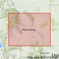
Equivalent to Maywood Formation. Name used in subsurface in eastern MT and northern WY, Central Montana uplift, Williston basin and Bighorn basin, whereas Maywood used in MT portion of Beartooth Mountains and to west of MT. Souris River is basal deposit of westward transgressing sea from Williston intracratonic basin; Maywood represents basal deposit of eastward transgressing sea from Cordilleran miogeosyncline. Seas coalesced in central and north-central MT early in Late Devonian, then spread south into northern WY. Figure 2 shows southern limit of unit in MT and along western flank of Bighorn Mountains in WY. At composite section at Cottonwood Canyon in Bighorn Mountains, Big Horn Co, WY, unit is 16 ft thick. Unconformably overlies Beartooth Butte Formation and conformably underlies lower member of Jefferson Formation. Correlation chart. Late Devonian age.
Source: GNU records (USGS DDS-6; Denver GNULEX).
For more information, please contact Nancy Stamm, Geologic Names Committee Secretary.
Asterisk (*) indicates published by U.S. Geological Survey authors.
"No current usage" (†) implies that a name has been abandoned or has fallen into disuse. Former usage and, if known, replacement name given in parentheses ( ).
Slash (/) indicates name conflicts with nomenclatural guidelines (CSN, 1933; ACSN, 1961, 1970; NACSN, 1983, 2005, 2021). May be explained within brackets ([ ]).