The National Geologic Map Database is migrating to a new infrastructure. We apologize for any service disruptions during this process.
|
|---|


- Usage in publication:
-
- Soldiers limestone member
- Modifications:
-
- Original reference
- Dominant lithology:
-
- Limestone
- AAPG geologic province:
-
- Llano uplift
- Permian basin
Summary:
Pg. 142, 143, 145; 1947, Jour. Geol., v. 55, no. 3, pt. 2, p. 196 (table 2), 197, 198. Soldiers limestone member of Big Saline formation. Consists of light-gray coarsely crystalline, massively bedded, crinoidal fossiliferous limestone. Thinnest southwest of Rochelle, thickens westward to 75 feet at Brady, and nearly 200 feet at Big Saline Creek, Kimble County, central Texas. West of Cavern Ridge, overlies Brook Ranch member (new) and, near Cavern Ridge, lies above beds with same lithology as that of Lemons Bluff spiculite at Lemons Bluff. Its stratigraphic position above beds of Lemons Bluff lithology suggests that Soldiers member has stratigraphic position similar to that of Brister member east of Cavern Ridge, although it differs from the Brister. Age is Early Pennsylvanian.
Source: US geologic names lexicon (USGS Bull. 1200, p. 3654-3655).
- Usage in publication:
-
- Soldiers Hole lentil [Soldiers limestone member]
- Modifications:
-
- Overview
- AAPG geologic province:
-
- Llano uplift
- Permian basin
Summary:
Pg. 70-71. Soldiers Hole lentil [Soldiers limestone member] is massive reef-like series of limestone beds that form upper layers of Big Saline formation in Kimble, Mason, and McCulloch Counties, central Texas. Extends from Big Saline Creek in Kimble County to Ellenburger ridges south of Hall near San Saba-McCulloch County line. Measured section at Soldiers Hole shows 25 feet of lentil above Lemons Bluff beds. Age is Early Pennsylvanian.
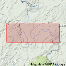
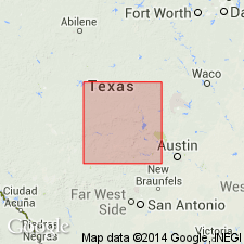
Soldiers Hole is 6 mi east and 2.5 mi north of Brady, McCulloch Co., TX.
Source: US geologic names lexicon (USGS Bull. 1200, p. 3654-3655).
For more information, please contact Nancy Stamm, Geologic Names Committee Secretary.
Asterisk (*) indicates published by U.S. Geological Survey authors.
"No current usage" (†) implies that a name has been abandoned or has fallen into disuse. Former usage and, if known, replacement name given in parentheses ( ).
Slash (/) indicates name conflicts with nomenclatural guidelines (CSN, 1933; ACSN, 1961, 1970; NACSN, 1983, 2005, 2021). May be explained within brackets ([ ]).