The National Geologic Map Database is migrating to a new infrastructure. We apologize for any service disruptions during this process.
|
|---|


- Usage in publication:
-
- Solberg schist*
- Modifications:
-
- Named
- Dominant lithology:
-
- Schist
- AAPG geologic province:
-
- Lake Superior region
Summary:
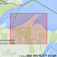
Named as middle unit of Dickinson group (new) for scattered outcrops that extend for about 10 mi in a belt 1 to 2 1/2 mi just east of Solberg Lake in secs 17 and 20, T42N, R29W, Dickinson Co, northwest MI in Lake Superior region. Is interlayered with Skunk Creek member (new). Some interbedding with East Branch arkose (new) near south edge. More westerly (stratigraphically lower) parts of unit are dark, fine-grained hornblende and biotite schists. Some exposures show a banding, parallel or near parallel to steeply dipping foliation. Southerly exposures are of a massive, gray, quartz-mica schist and micaceous quartzite. Aggregate thickness estimated to be about 3,000 ft. Above East Branch arkose and below Six-Mile Lake amphibolite (new). Stratigraphic sequence chart. Is considered pre-Animikie in age; assigned to early Precambrian.
Source: GNU records (USGS DDS-6; Reston GNULEX).
For more information, please contact Nancy Stamm, Geologic Names Committee Secretary.
Asterisk (*) indicates published by U.S. Geological Survey authors.
"No current usage" (†) implies that a name has been abandoned or has fallen into disuse. Former usage and, if known, replacement name given in parentheses ( ).
Slash (/) indicates name conflicts with nomenclatural guidelines (CSN, 1933; ACSN, 1961, 1970; NACSN, 1983, 2005, 2021). May be explained within brackets ([ ]).