The National Geologic Map Database is migrating to a new infrastructure. We apologize for any service disruptions during this process.
|
|---|


- Usage in publication:
-
- Soda Lake [formation]
- Modifications:
-
- Named
- Dominant lithology:
-
- Shale
- Sandstone
- AAPG geologic province:
-
- California Coast Ranges province
Summary:
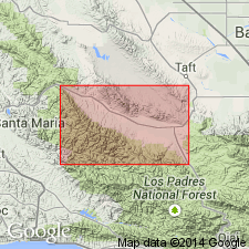
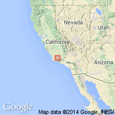
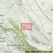
Occurs in Caliente Range, low mountainous ridge trending northwesterly for about 30 miles between Cuyama Valley and Carrizo Plain, California. Range is anticlinal uplift developed in thick series of Tertiary sediments and is partially overturned and thrust-faulted southwestward toward Cuyama Valley. Consists of 1200 feet thick marine shale and basal sandstone. Underlies Painted Rock formation (new); overlies Simmler formation (new). Outcrops noted in road log. [This appears to be unit that was defined by Hill and others (1958) as their Soda Lake Shale and Soda Lake Sandstone Members of Vaqueros Formation.] Age is early Miocene.
Source: Modified from GNU records (USGS DDS-6; Menlo GNULEX).
- Usage in publication:
-
- Soda Lake sandstone, shale members
- Modifications:
-
- Named
- Dominant lithology:
-
- Sandstone
- Shale
- AAPG geologic province:
-
- California Coast Ranges province
Summary:
Sandstone member crops out in southeast Caliente Range where it is lowest of three members of Vaqueros formation, above Simmler formation, conformably below Soda Lake shale member. Is 300 feet thick at type. Thins westward and probably gradates into conformably overlying Soda Lake shale member. Towards the southeast it becomes undifferentiated from overlying Painted Rock sandstone member. Is gray-white, weathering to light buff, massive bedded, fine- to medium-grained, well-sorted and commonly cross-bedded. Shale member crops out in northwestern Caliente Range near Soda Lake (in T. 31 S., R. 19 E.), Simmler quadrangle, San Luis Obispo County, California. Shale member is hard, gray to black, well bedded, argillaceous to silty, micaceous shale. Thickness in type area is 1,200 feet. Age of sandstone member is early Miocene (Zemorrian). Age of shale member is early Miocene (Saucesian).
Type locality of sandstone member: Quail Canyon, NW/4 SW/4 sec. 4, T. 10 N., R. 25 W., southeast Caliente Range, Cuyama quadrangle, southwest San Luis Obispo Co., CA (citing Dibblee, 1973).
Source: Modified from GNU records (USGS DDS-6; Menlo GNULEX).
- Usage in publication:
-
- Soda Lake Shale Member*
- Modifications:
-
- Adopted
- Age modified
- Biostratigraphic dating
- AAPG geologic province:
-
- California Coast Ranges province
Summary:
Soda Lake Shale Member of Vaqueros Formation of Hill and others (1958) is adopted. Contains foraminifers diagnostic of Zemorrian and Saucesian Stages. Age is considered to be late Oligocene and early Miocene.
Source: GNU records (USGS DDS-6; Menlo GNULEX).
- Usage in publication:
-
- Soda Lake Shale Member*
- Modifications:
-
- Age modified
- Biostratigraphic dating
- AAPG geologic province:
-
- California Coast Ranges province
Summary:
Age is early Miocene based on planktonic microfossils (foraminifers) in lower part of the type section.
Source: GNU records (USGS DDS-6; Menlo GNULEX).
For more information, please contact Nancy Stamm, Geologic Names Committee Secretary.
Asterisk (*) indicates published by U.S. Geological Survey authors.
"No current usage" (†) implies that a name has been abandoned or has fallen into disuse. Former usage and, if known, replacement name given in parentheses ( ).
Slash (/) indicates name conflicts with nomenclatural guidelines (CSN, 1933; ACSN, 1961, 1970; NACSN, 1983, 2005, 2021). May be explained within brackets ([ ]).