

- Usage in publication:
-
- Soapstone Formation
- Modifications:
-
- Named
- Dominant lithology:
-
- Shale
- Limestone
- Siltstone
- AAPG geologic province:
-
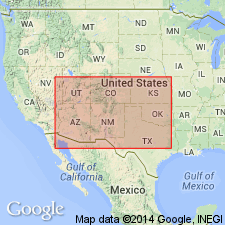
- Uinta basin
Summary:
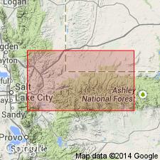
Named for Soapstone basin, Wasatch Co., UT in the Uinta basin. Type locality (also called section) is in N1/2 sec 31, T3S, R9E. Also known in Summit Co. Extends throughout the Uinta Mountains and south almost to Uncompahgre Plateau. Is chiefly dark-gray, fissile, clayey shale with minor gray limestone and red-brown to yellow-brown, calcareous siltstone. Has a gray limestone pebble conglomerate at base. Averages 300 ft thick. Maximum thickness of 550 ft thick. Overlies Humbug Formation unconformably; underlies Round Valley Formation. Correlates with Manning Canyon Formation and with the Great Blue Formation. Has fossil brachiopods and flora. Is one of the few Mississippian formations in North America with fossil plants.
Source: GNU records (USGS DDS-6; Denver GNULEX).
- Usage in publication:
-
- Soapstone Formation
- Modifications:
-
- Biostratigraphic dating
- Areal extent
- AAPG geologic province:
-
- Uinta basin
Summary:
Section of Soapstone Formation is exposed in SW/4 SW/4 sec.31 T3S R9W, Deep Creek Canyon quad, Wasatch Co, UT. Age is Late Mississippian (Chesterian) on the basis of conodonts.
Source: GNU records (USGS DDS-6; Menlo GNULEX).
For more information, please contact Nancy Stamm, Geologic Names Committee Secretary.
Asterisk (*) indicates published by U.S. Geological Survey authors.
"No current usage" (†) implies that a name has been abandoned or has fallen into disuse. Former usage and, if known, replacement name given in parentheses ( ).
Slash (/) indicates name conflicts with nomenclatural guidelines (CSN, 1933; ACSN, 1961, 1970; NACSN, 1983, 2005, 2021). May be explained within brackets ([ ]).