The National Geologic Map Database is migrating to a new infrastructure. We apologize for any service disruptions during this process.
|
|---|


- Usage in publication:
-
- Snowcrest granite
- Modifications:
-
- Named
- Dominant lithology:
-
- Granite
- AAPG geologic province:
-
- Montana folded belt
Summary:
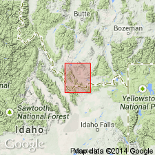
Name applied to a small stock which crops out at southwest end of Snowcrest Range, sec 20, T13S, R7W, Beaverhead Co, MT in the Montana folded belt province. Shown on geologic map as Ti, a Tertiary granitic intrusive. The granite is coarse grained, has abundant quartz and feldspar, little biotite. It is strongly jointed and weathers into small angular fragments. Consists of about 54 percent orthoclase, 19 percent sodic plagioclase, 25 percent quartz, 2 percent biotite in thin section. Feldspar is strongly kaolinized. Cuts Mississippian rocks. Unconformably overlain by Blacktail Deer Creek formation. May be consanguineous with the Beaverhead pluton. Tentatively assigned to the Eocene.
Source: GNU records (USGS DDS-6; Denver GNULEX).
For more information, please contact Nancy Stamm, Geologic Names Committee Secretary.
Asterisk (*) indicates published by U.S. Geological Survey authors.
"No current usage" (†) implies that a name has been abandoned or has fallen into disuse. Former usage and, if known, replacement name given in parentheses ( ).
Slash (/) indicates name conflicts with nomenclatural guidelines (CSN, 1933; ACSN, 1961, 1970; NACSN, 1983, 2005, 2021). May be explained within brackets ([ ]).