The National Geologic Map Database is migrating to a new infrastructure. We apologize for any service disruptions during this process.
|
|---|


- Usage in publication:
-
- Snaky Canyon Formation*
- Modifications:
-
- Named
- Dominant lithology:
-
- Limestone
- Sandstone
- Dolomite
- AAPG geologic province:
-
- Idaho Mountains province
Summary:
Pg. 2, 4, 20-32, figs. 1-6. Snaky Canyon Formation. Present in White Knob Mountains, southern Lost River Range-Arco Hills, southern Lemhi Range, southern and central Beaverhead Mountains, south-central Idaho. Divided into (ascending) Bloom Member, Gallagher Peak Sandstone Member, and Juniper Gulch Member (all new). Consists mostly of carbonate rocks interbedded with thin calcareous sandstones. The carbonates are medium- to light-gray, medium- to thin-bedded, microcrystalline to medium-grained limestone and dolomite which are sandy and silty. They are variably fossiliferous. The thin calcareous sandstones are medium-gray, pale grayish-red, and grayish-orange, weather light-olive-gray, light-gray and light-brown, and are very fine- to fine-grained. A prominent thin sandstone unit (Gallagher Peak Sandstone Member) about 195 feet (59 m) thick, which divides the formation approximately in half, is present locally in the southern Lost River and Lemhi Ranges, and the southern Beaverhead Mountains. Thickness about 3,940 feet (1,200 m) at type. Gradationally overlies Bluebird Formation (new); conformably underlies Permian Phosphoria Formation. Is Shannon's (1961, GSA Bull., v. 72, no. 12) units D and E of southern Lost River and Lemhi Ranges; unnamed units of Mapel and others (1965, Doublespring quadrangle) and Mapel and Shropshire (1973, Hawley Mountain quadrangle). Age is Late Mississippian to Early Permian (late Chesterian to Wolfcampian), based on fossils. Authors propose an arbitrary northern limit for the Arco Hills, Bluebird Mountain, and Snaky Canyon Formations at about Lat. 44 deg. 30 min. N.; volcanic rocks along northeast margin of Snake River Plain provide natural southern limit. Report includes correlation chart, measured sections, fossil list, geologic sketch map.
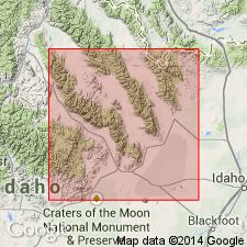
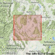
Type section (composite of individual members): (1) Bloom Member, about 3.5 mi (5.8 km) south of Bluebird Mountain on west flank of Gallagher Peak and on east side of saddle between Copper Mountain and Gallagher Peak, in secs. 29 and 30 (unsurveyed), T. 10 N., R. 31 E., [in vicinity of Lat. 44 deg. 10 min. 17 sec. N., Lat. 112 deg. 48 min. 19 sec. W.], Copper Mountain 7.5-min quadrangle, [Targhee National Forest], Clark Co., ID; (2) Gallagher Peak and Juniper Gulch Members, about halfway between Snaky Canyon and Juniper Gulch, in sec. 21, T. 9 N., R. 32 E., [in vicinity of Lat. 44 deg. 05 min. 26 sec. N., Long. 112 deg. 42 min. 22 sec. W.], Snaky Canyon 7.5-min quadrangle, [Targhee National Forest], Clark Co., ID. Named from Snaky Canyon. [Additional locality information from USGS GNIS database and ACME Mapper 2.0, accessed on Darwin's 200th birthday, 2009.]
[Misprint: thickness given in US geologic names lexicon (USGS Bull. 1564, p. 161) is incorrect.]
Source: Publication; US geologic names lexicon (USGS Bull. 1564, p. 161); Changes in stratigraphic nomenclature, 1979 (USGS Bull. 1502-A, p. A72).
- Usage in publication:
-
- Snaky Canyon Formation*
- Modifications:
-
- Biostratigraphic dating
- AAPG geologic province:
-
- Idaho Mountains province
Summary:
The Mississippian-Pennsylvanian, or Chesterian-Morrowan boundary lies in the basal beds of the Bloom Member, the basal member of the Snaky Canyon Formation in the Wood Canyon and Timbered Dome sections, White Knob Mountains, Custer Co, ID in the Idaho Mountains province. Northeastward from these sections to Gallagher Peak in Beaverhead Mountains, ID, the system boundary rises and the Bloom is only Morrowan in age. The Bloom is part of a continuous sedimentary sequence and part of an extensive carbonate bank deposit that developed in east-central ID from Early Mississippian lasting until Permian time. Placement of the system boundary is documented by collections of foraminifers and associated conodont faunas, and brachiopod fossils. Authors use RHACHISTOGNATHUS PRIMUS DUNN (conodont) as an indicator of the Mississippian-Pennsylvanian boundary; this conodont was found 8.5 m above the base of the Bloom at Wood Canyon and 1.5 m above the base of Bloom at Timbered Dome. Fossils listed. Columnar sections.
Source: GNU records (USGS DDS-6; Denver GNULEX).
- Usage in publication:
-
- Snaky Canyon Formation
- Modifications:
-
- Areal extent
- Biostratigraphic dating
- AAPG geologic province:
-
- Montana folded belt
Summary:
Extended into Morrison Lake area, Beaverhead Mountains, Beaverhead Co, MT, Montana folded belt province. Replaces Quadrant Formation. Lithologically, rocks are more similar to predominantly carbonate Snaky Canyon in southern part of Beaverhead Mountains and in Lost River and Lemhi Ranges of east-central ID than to thick sandstones and quartzites of Quadrant. Fusulinids of late Atokan (EOSCHUBERTELLA sp. and FUSULINELLA aff. F. ACUMINATA Thompson), early Desmoinesian (PSEUDOSTAFFELLA sp., PLECTOFUSULINA sp., WEDEKINDELLINA HENBESTI (Skinner), and FUSULINA sp.), Missourian (EOWAERINGELLA sp., KANSANELLA aff. K. TENUIS), and Virgilian (TRITICITES spp.) age occur in the Snaky Canyon in the Morrison Lake area; there is no fusulinid evidence supporting a Permian age. Measured section and fossil figures.
Source: GNU records (USGS DDS-6; Denver GNULEX).
For more information, please contact Nancy Stamm, Geologic Names Committee Secretary.
Asterisk (*) indicates published by U.S. Geological Survey authors.
"No current usage" (†) implies that a name has been abandoned or has fallen into disuse. Former usage and, if known, replacement name given in parentheses ( ).
Slash (/) indicates name conflicts with nomenclatural guidelines (CSN, 1933; ACSN, 1961, 1970; NACSN, 1983, 2005, 2021). May be explained within brackets ([ ]).