The National Geologic Map Database is migrating to a new infrastructure. We apologize for any service disruptions during this process.
|
|---|


- Usage in publication:
-
- Smoot Formation
- Modifications:
-
- Named
- Dominant lithology:
-
- Mudstone
- Siltstone
- Shale
- AAPG geologic province:
-
- Green River basin
- Snake River basin
- Wasatch uplift
Summary:
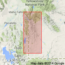
Name applied to a previously unnamed red calcareous mudstone at the top of the Gannett Group. Type section designated, measured, and described at NW1/4 T29N, R118W, along U.S. 86 south of Smoot in Lincoln Co, WY in the Greater Green River basin. Is 313.4 ft thick at type where it consists of red-brown and gray-red mudstone that may be silty or calcareous. Fossils at type: charophytes, ostracods. Overlies Draney Limestone of Gannett and underlies Tygee Member, newly removed from Gannett and reassigned to Bear River Formation as its basal member. Also contains calcareous nodules, siltstone, and shale. Is generally covered or poorly exposed, but both contacts distinguishable. Lower contact placed at top of uppermost limestone bed of Draney. Upper contact placed at base of a lower black shale of Tygee. Thickness of 80 ft south of East Fork at Turkey Creek to 300 ft north of Salt River Pass reported. Isopach map. Includes fresh-water beach deposits, fluvial and lacustrine deposits. Time of deposition probably spans the Aptian-Albian boundary. Of Early Cretaceous age. Cross sections; Smoot occurs in Bonneville (Snake River basin), Caribou and Bear Lake (Wasatch uplift) Cos, ID, and adjoining Lincoln and Uinta (Greater Green River basin) Cos, WY. Confined to the thrust belt areas of these two states.
Source: GNU records (USGS DDS-6; Denver GNULEX).
For more information, please contact Nancy Stamm, Geologic Names Committee Secretary.
Asterisk (*) indicates published by U.S. Geological Survey authors.
"No current usage" (†) implies that a name has been abandoned or has fallen into disuse. Former usage and, if known, replacement name given in parentheses ( ).
Slash (/) indicates name conflicts with nomenclatural guidelines (CSN, 1933; ACSN, 1961, 1970; NACSN, 1983, 2005, 2021). May be explained within brackets ([ ]).