The National Geologic Map Database is migrating to a new infrastructure. We apologize for any service disruptions during this process.
|
|---|


- Usage in publication:
-
- Smith Basin formation
- Modifications:
-
- Original reference
- Dominant lithology:
-
- Dolomite
- AAPG geologic province:
-
- New England province
Summary:
Pg. 35 (table 2). Smith Basin formation. Described as cherty dolomite with limestone layers below the dolomite. Thickness 90 feet. Underlies Fort Cassin formation. Age is Early Ordovician. Refers to R.H. Flower (unpub. ms.).
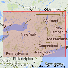
Occurs in Fort Ann quadrangle, east-central NY.
Source: US geologic names lexicon (USGS Bull. 1200, p. 3636).
- Usage in publication:
-
- Smith Basin Member
- Modifications:
-
- Revised
- AAPG geologic province:
-
- New England province
Summary:
Smith Basin Member of Cutting Hill Formation [Cutting Formation of Cady (1945) redefined and renamed] of Bascom subgroup [informal] of Beekmantown Group. Formerly called "member 1 of Division D" by Brainerd and Seely (1890). Assigned to Cutting Hill based on strong faunal connection with underlying dolostones and strong association with paleokarst unconformity at top of the Cutting Hill.
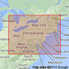
Best outcrops in study area occur on east side of Cutting Hill, Addison Co., VT.
["Subgroup" not recognized as a formal stratigraphic rank term (CSN, 1933; ACSN, 1961, 1970; NACSN, 1983, 2005, 2021). Considered informal and should not be capitalized.]
Source: Modified from GNU records (USGS DDS-6; Reston GNULEX).
For more information, please contact Nancy Stamm, Geologic Names Committee Secretary.
Asterisk (*) indicates published by U.S. Geological Survey authors.
"No current usage" (†) implies that a name has been abandoned or has fallen into disuse. Former usage and, if known, replacement name given in parentheses ( ).
Slash (/) indicates name conflicts with nomenclatural guidelines (CSN, 1933; ACSN, 1961, 1970; NACSN, 1983, 2005, 2021). May be explained within brackets ([ ]).