

- Usage in publication:
-
- Slim Sam formation
- Modifications:
-
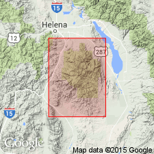
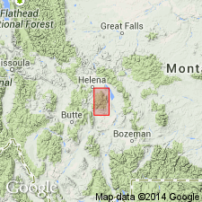
- Areal extent
- AAPG geologic province:
-
- Montana folded belt
Summary:
Pg. 9. Slim Sam formation. Name mentioned in a discussion of the iron deposits in Montana.
Source: US geologic names lexicon (USGS Bull. 1200, p. 3631).
- Usage in publication:
-
- Slim Sam formation*
- Modifications:
-
- Principal reference
- Dominant lithology:
-
- Sandstone
- Shale
- Tuff
- Mudstone
- AAPG geologic province:
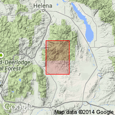
-
- Montana folded belt
Summary:
Pg. 4 (table), 26 (table), 28-31, pl. 1. Slim Sam formation. Described as sequence of coarse-grained clastic rocks. Lower part of sequence consists predominantly of gray, greenish-gray, and yellowish-gray quartz-chert sandstone and upper part of feldspathic quartz- and chert-poor sandstone with abundant beds of tuff and sedimentary tuff near the top. Thickness 800 to 1,200 feet. Underlies Elkhorn Mountains volcanics (new) with local unconformity; contact arbitrarily placed at base of lowest coarse-textured pyroclastic. Overlies Colorado formation. Age is Late Cretaceous.
Named from exposures along east margin of Slim Sam basin, in sec. 22, T. 6 N., R. 1 W., Elkhorn Mountains, Broadwater Co., southwestern MT, about 1 mi east of map area.
Source: US geologic names lexicon (USGS Bull. 1200, p. 3631); supplemental information from GNU records (USGS DDS-6; Denver GNULEX).
- Usage in publication:
-
- Slim Sam Formation*
- Modifications:
-
- Revised
- Reference
- AAPG geologic province:
-
- Montana folded belt
Summary:
Slim Sam Formation. Restricted to the upper part of the Slim Sam as originally defined by Klepper and others (1957). Consists of nonmarine volcanic and volcaniclastic rocks. Thickness 508 to 659 feet. Lower part of Klepper and others' Slim Sam = (descending) Eagle Sandstone and Telegraph Creek Formation (geographically extended into study area). Unconformably overlies Eagle Sandstone; conformably underlies Elkhorn Mountains Volcanics. Recognized in Elkhorn Mountains area, Jefferson and Broadwater Counties, southwestern Montana. Age is Late Cretaceous (Campanian).
Reference section (starting at about 400 feet above base of Indian Creek section of Klepper and others, 1957, p. 30-31): in N/2 SW/4 and S/2 NW/4 sec. 6, T. 6 N., R. 1 E., Elkhorn Mountains, south-central MT; [along Indian Creek, southeast of town of Hassel, approx. Lat. 46 deg. 18 min. 12 sec. N., Long. 111 deg. 39 min. 20 sec. W., Giant Hill 7.5-min quadrangle, Broadwater Co.].
Source: Publication.
For more information, please contact Nancy Stamm, Geologic Names Committee Secretary.
Asterisk (*) indicates published by U.S. Geological Survey authors.
"No current usage" (†) implies that a name has been abandoned or has fallen into disuse. Former usage and, if known, replacement name given in parentheses ( ).
Slash (/) indicates name conflicts with nomenclatural guidelines (CSN, 1933; ACSN, 1961, 1970; NACSN, 1983, 2005, 2021). May be explained within brackets ([ ]).