

- Usage in publication:
-
- Sliderock Member*
- Modifications:
-
- Named
- Dominant lithology:
-
- Limestone
- AAPG geologic province:
-
- Snake River basin
- Wasatch uplift
- Yellowstone province
- Green River basin
- Uinta basin
- Uinta uplift
Summary:
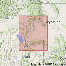
Named as one of seven members of Twin Creek Limestone for Slide Rock Creek, NE1/4 sec 10, T25N, R118W (type section), Lincoln Co, WY in Greater Green River basin. Previously called member B of Twin Creek. Thickens westward from 21 ft in Jackson Hole, WY, Yellowstone province, to 285 ft in southeast ID in Snake River basin. In UT thickens west from 32 ft near Lake Fork, Duchesne Co, UT in Uinta basin to 150 ft at Burr Fork in Utah Co, on Wasatch uplift. Also occurs in Greater Green River basin and on Uinta uplift. Six measured sections. Consists mainly of medium- to thin-bedded grayish-black to brownish-gray, dense to granular limestone. A basal 5-15 ft oolite present in WY. In ID basal 20-60 ft is usually brown glauconitic, sandy cross-bedded limestone. Basal units in UT are oolitic or sandy or both. Rests sharply on red beds or brecciated limestone of Gypsum Spring Member of Twin Creek. Overlain gradationally by shaly limestone of Rich Member (new) of Twin Creek. Extensive listing of marine fossils (cephalopods, pelecypods, gastropods, crinoids, echinoid spines, worm tubes). Of Middle Jurassic, late Bajocian age. A shallow-water marine deposit. Cross sections. Correlation with lower parts of Sundance Formation (WY), Arapien Shale (UT) and Carmel Formation (UT), and with Sawtooth (MT) shown on chart.
Source: GNU records (USGS DDS-6; Denver GNULEX).

- Usage in publication:
-
- Sliderock Member*
- Modifications:
-
- Overview
- Areal extent
- Age modified
- AAPG geologic province:
-
- Snake River basin
- Yellowstone province
- Uinta basin
- Wasatch uplift
- Uinta uplift
Summary:
Recognized as a member (one of seven members) of the Twin Creek Limestone unconformably above the Gypsum Spring Member and conformably below the Rich Member of the Twin Creek everywhere except in Duchesne Co, UT in the Uinta basin where it rests on the Glen Canyon Sandstone. Occurs in the Snake River basin, ID, Yellowstone province, WY, Wasatch uplift, Uinta basin, and Uinta uplift, UT. [Occurs also in southwest WY in the Greater Green River basin.] Correlation charts include information on thickness and general lithology. Correlative formations to east and south are Sundance, Piper, Carmel, and Page. Is a shallow water normal marine deposit of middle and late Bajocian, Middle Jurassic age.
Source: GNU records (USGS DDS-6; Denver GNULEX).
For more information, please contact Nancy Stamm, Geologic Names Committee Secretary.
Asterisk (*) indicates published by U.S. Geological Survey authors.
"No current usage" (†) implies that a name has been abandoned or has fallen into disuse. Former usage and, if known, replacement name given in parentheses ( ).
Slash (/) indicates name conflicts with nomenclatural guidelines (CSN, 1933; ACSN, 1961, 1970; NACSN, 1983, 2005, 2021). May be explained within brackets ([ ]).